DATE: Monday, June 29, 2020
DISTANCE: 19.31km / 12 miles
ELEVTION GAIN: 1252m / 4107 ft.
ELEVATION LOSS: 1039m / 3408 ft.
TIME: 9:35
STANISLAUS NATIONAL FOREST
EMMIGRANT WILDERNESS
HUMBOLDT TOIYABE NATIONAL FOREST
TUOLUMNE COUNTY, CA
MONO COUNTY, CA
SOUNDTRACK: Blood Of Kings: Starvation
SUMMITS:
“Deadman Butte”: 3097+ m / 10,160+ ft.
Leavitt West: 3496m / 11,470ft.
Leavitt Peak: 3526m / 11,569 ft. SPS
“Latopie Peak” (attempt): 3432m / 11,260 ft.
“Pacific Crest Peak”: 3427m / 11,245ft.
PHOTO ALBUM
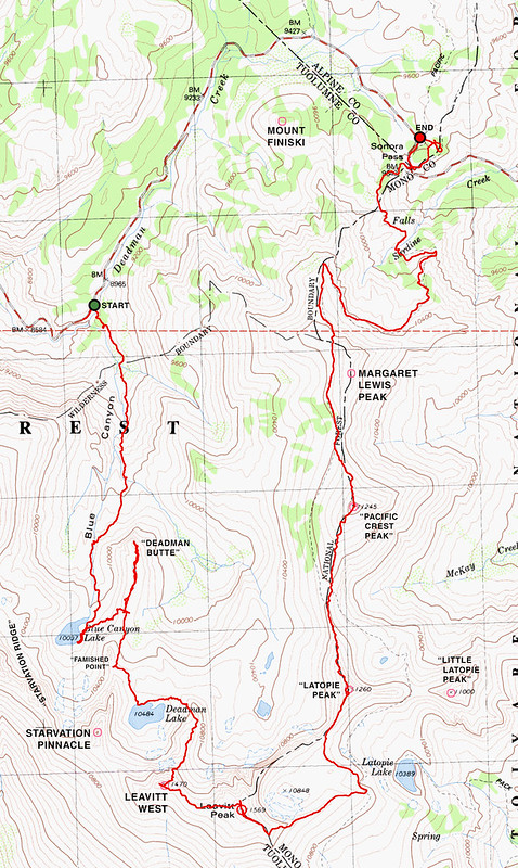
MAP
Leavitt Peak is a rounded mountain on the south side of Sonora Pass, rising to 11,570 feet. I had been thinking about going to Leavitt Peak at least since the beginning of the year, if not longer, for two main reasons: Number one: I wanted to climb a peak over 11,000 feet for the first time, and Leavitt was one of the farthest north and most easily accessible. Number two: I was captivated by the description of the Blue Canyon Trail in Heid’s 101 Hikes In Northern California, and I realized I could use this path as an access point for Leavitt Peak. Leavitt is most commonly accessed as an easy side trip from the PCT, on it’s east side, but the Blue Canyon route is a fabulously scenic alternative. This was my first time hiking in the area, and I saw a lot of new things, so apologies in advance, this trip report is going to be long. If you want, you can just skip to the end. (SPOILER ALERT: I camped at Chipmunk Flat again)

I left the Bay Area with my younger brother Axell and his dog Zuma pretty late at night on Sunday, June 28 and headed for Sonora Pass through the hot cowshit breezes of the Central Valley, the Miwok meadows of the foothills, and the pines of the Sierras. After a couple of passes, we were able to locate the unmarked entrance to Chipmunk Flat campground, and crashed out almost immediately in the van. Guided to sleep by twinkling starlight and the sound of Deadman Creek rushing through the background. Awake again by 7AM,
sunlight had revealed the
surrounding granite majesty of the location, towering peaks and cliffs over the canyon, yet another
spectacular campground discovered! Breakfast was bananas and cereal, at
the trailhead, and we were hiking before 8:30AM. The plan was to hike up the trail to Blue Canyon Lake, then to Deadman Lake, up to Leavitt Peak, down to Sonora Pass via the PCT, and then walk down the highway back to the van from there. Before starting off on Blue Canyon Trail, we had a quick look at
the waterfall of Deadman Creek, just down the highway. This is a good landmark if you're searching for the trailhead, which is unmarked, located at a dirt turnout
on Highway 108 with room for maybe two cars, just before the 9,000 foot elevation sign. To begin the hike, the creek below the road was crossed, which was easy this time of year, but I’ve read that sometimes it’s not.
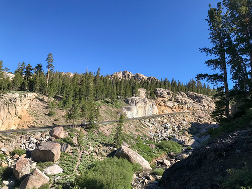
The trail, although seemingly unofficial, was pretty easy to follow, aside from the few parts that were still covered in snow. Almost immediately
the first notable geological feature
came into view, towering over the canyon, a blunted, blackened thing, a
cauterized stump of rock that blindly ruled it’s domain. We ended up
nicknaming it “Deadman Butte.” It’s nice to have a hiking buddy to bounce ideas off of. There were
multiple small waterfalls, side creeks joining in,
steeper parts of the trail over some loose talus, and ever increasing views of the surrounding
brutal volcanic landscape. As we continued, we soon realized that Deadman Butte, although impressive, was only the beginning. Up ahead,
more jagged volcanic spires came into view, including the only one that seems to have been named: Starvation Pinnacle. To our right (the west) the jumbled chaos of volcanic rock continued. Epic jagged crags lined the skyline, dyed black, brown, grey green, orange and even pink by the variety of mineral deposits and lichens. The variety of colors would have made the sight downright festive, had the shapes of the peaks themselves not suggested a swift and morbid death awaiting.

By 9:45AM, we arrived at
Blue Canyon Lake, ringed by the talus slopes of the aforementioned volcanic peaks. The water was cold and clear, and snow came right down to the edge in some places.
“Famished Point” and
“Starvation Ridge,” as we chose to nickname them, towered above. Zuma was having a good time grabbing rocks out of the lake with his mouth, sticking his snout in the snowbanks, and doing other dog things that are just impossible in the urban jungle of San Francisco. Now at the top of the canyon, we had a good
view back north down the canyon, all the way to Stanislaus Peak and beyond. We decided to pay a visit to “Deadman Butte,” which had looked formidable from the front, but was an easy walkup on the back side. The view over the canyon was
even better from up here, and it was around this time that Axell the rockhound, much to his delight, began finding multiple mineral specimens of note. A worthy side trip indeed! After this, Axell was more preoccupied with collecting rocks than climbing the peaks, so good for him! Everybody wins.

After this, it was “cross country,” over the intermediate ridge to get to Deadman Lake, but a use trail appeared from time to time. Due to the hanging out, photographing, rock collecting and side trip to “Deadman Butte,” we didn’t get up to
Deadman Lake until after 11:30AM. It was
quite a sight it’s self: secluded, barren, a blue mirror in a rock bed, ice still floating in it. From there, we pushed on, around the north side of the lake, and then up the ridge on it’s southeast side. This is where the real cross country began, and then going got quite steep. I was forced to slow down and catch my breath quite often.
Sweeping views of the the volcanic wonderland never ceased. Imposing cliffs of Leavitt Peak's
north face came into view for the first time. From here, we saw the only other human being of the whole day, a tiny silhouette on the top of the mountain, who was long gone by the time I got there. We
continued up the ridge toward Leavitt West. At some point, the terrain began to get too sketchy for the dog, and
Axell decided he would go back down, return to the van, and meet me at Sonora Pass later in the day. So I bid them adieu, and continued on my way, alone. By this point, the ridge climb was almost completed. It was
chunky talus and rocks that bordered on class three for a
moment, and then all of the sudden I was up
on top of Leavitt West,
my first 11,000 foot peak! Walking
across the saddle to Leavitt Peak, I had a fine overview of the areas I had hiked through that day.

I was on top of Leavitt Peak by 1:30PM, and I searched all over it’s
flat rocky top for a summit register that I knew was supposed to be there. Couldn’t find it. By now it was time for a break so I sat down, and had a snack. Almost lost my hat to the high winds, and did lose a cliff bar wrapper. Sorry nature, I am a fucking accidental litterer. The view (
west-north-northeast-east-south) was nothing to complain about. I was especially excited to have a look to the south, which had until this point been blocked by Leavitt. Jagged mountains stretched out to the horizon, but I was able to pick out Tower Peak from the chaos, a mighty crag that I hoped to visit later in the summer. Having a pretty good ways to go still, I soon hit the road, and headed southeast
down from Leavitt, down the use trail that had been formed by PCT-ers coming up. The original idea had been to scramble across the ridge from Leavitt Peak to
“Latopie Peak,” (Peak 11,260) but it looked sketchy, so I went down and followed the PCT, across a large
remaining snow field, to a point where I had an easy approach to "Latopie.". Preparing for the trip at home, looking at the internet and the topo maps, I had formed a plan where I would stick mostly to the ridgeline, going from Leavitt to “Latopie Peak” to “Little Latopie” (Peak 11,000), to “Pacific Crest Peak” (Peak 11,245) to Margaret Lewis, using the PCT only when it was convenient. I had to see these mountains in real life to realize how unrealistic that plan was.
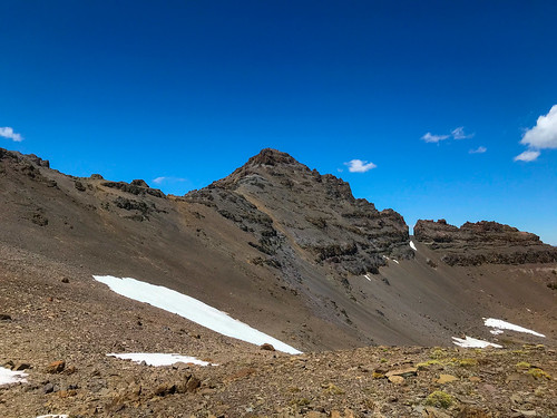
My first lesson in reality came from being denied the summit of Latopie Peak. It looked pretty jagged from afar, but I thought I had read that it was a class 2/3 summit, so I approached full of confidence. The first thing I noticed was that the planned ridge crossing from Latopie to “Little Latopie” would be near impossible, if not for the
jagged volcanic ridge, then certainly for the massive Y-shaped gap. No matter, I proceeded easily to the summit block of Latopie, and here my problems began. I could see now that there was a pretty
big cliff on the north-east side, so I went around to the west side. The summit block looked unclimbable, for my skill level, every approach I could see. I found a spot that
looked better, at least with solid handholds, in the otherwise loose volcanic rock. I climbed up, but couldn’t make the last few feet, too much exposure, and I pussed out. I continued around the west side of the summit, looking for a better way up. I had to take my damn time, it was all loose, tedious scree that I really didn’t want to slide down out of control, because there were steep cliffs below that. Clutching a ledge of more solid rock as I dragged myself along, I found a
geode just sitting there, in four pieces, I guess that would be my consolation prize. I carefully stuffed them into my bag, incidentally becoming a rock collector myself! Anyway, I never found a good way up the Latopie summit block. When I got to north side of the peak, it was already 3:20PM, and clouds had come in, creating the illusion that I was running out of daylight. I took
one last look back at the crag, and it looked easier to climb from this direction, it’s probably the way that people usually ascend it, but by now I was over it, ready to move on. I probably would have been more bold if I hadn’t been all alone.

I went
straight north off of “Latopie Peak” and crossed the PCT on my way to “Pacific Crest Peak,” which from now on shall be referred to as “PC Peak.” I was determined to climb at least one more mountain, and I could tell that this one was actually a walk up, an easy target. So up I went. There was a good view out to the east now, the
Sweetwater Range in the distance, and closer,
“Little Latopie” which looked like quite a challenge to get up, nasty crumbles of rock and talus on all sides. Perhaps someday we’ll see… Anyway, I continued up
“PC Peak” unobstructed. It was rocky, but gently sloped, and still over 11,000 feet at the top. And what a panorama! This was my first wide open view to the
west, back towards Blue Canyon where I had originated, and down the valley from which highway 108 comes up. Good view back south at the
Latopie Peaks too. I
angled slightly NW off of “PC Peak” and soon rejoined
the PCT again, which I would follow all the way north to Sonora Pass from hereon. I had a 6PM rendezvous to maintain, and it was almost five now, so I avoided the temptation to climb Margaret Lewis Peak. I diligently stuck to the well worn PCT, crossed the
wilderness boundary, and began the descent,
afternoon clouds rushing over the pacific crest right above me.

It was nice to have a solid trail, and there was a great
view to the north of Stanislaus and Sonora Peaks, with the pass below. When I got to
the pass, at 5:51PM, I didn’t know which parking area Axell was going to arrive in, so I walked all round the whole area, and then around again because I couldn’t find him. The reason I couldn’t find him of course was because he was a fucking hour late for the meetup, but that’s not unusual if you know this kid, and I didn’t even give him any shit for it. Apparently he had found some difficulties descending off of the off the ridge where I had left him, and then he tried returning to the trailhead via a different canyon, which didn’t turn out so well. He came out in the end handsomely rewarded with mineral samples though, all kinds of crystals and things which he showed me in the van. We went
back to Chipmunk Flat, where we formulated a plan that prioritized going to Stanislaus Peak instead of Sonora Peak the next day. Stanislaus Peak looks cooler! We cooked dinner and drank some beers, built a camp fire even though we weren’t sure if it was allowed or not. Then it got into this awkward hour that I haven’t figured out how to deal with yet: It gets dark, there’s nothing to really do except go to sleep early, and I suck at going to sleep early, no matter how tired I am. The pandemic has essentially eliminated rock and roll from my life, but my body stubbornly remains on rock and roll schedule. Oh well.
ON PEAK NAMES
"Deadman Butte" We decided to nickname it this because it's near Deadman Creek and lake. Also, it's a fittingly morbid name for such a sinister rock.
"Starvation Pinnacle" This isn't an official name on the map, but this is what someone named it on Peakbagger.
"Famished Point" Continuing the hunger theme, Axell nicknamed the smaller pinnacle in front of Starvation.
"Starvation Ridge" Nicknamed it because it's the continuation of the jagged ridge leading away from the pinnacle.
"Latopie Peak" Not an official name, but so called on Summitpost.
"Little Latopie Peak" Not an official name, but so called on Summitpost.
"Pacific Crest Peak" Not an official name, but so called on Summitpost. Also called "McKay Peak" in THIS trip report.
"Margaret Lewis Peak" Not an official name, but so called on Peakbagger. Apparently nicknamed for someone's deceased family matriarch.
FURTHER READING
•Bob Burd: Bob approaches Leavitt Peak from Blue Canyon
•Summitpost: The "Northwest Ridge" approach to Leavitt
•Fedak: Leavitt Peak from Blue Canyon
•Peaks For Freaks: Leavitt, Latopie, PC Peak, etc.
• 101 Hikes In Northern California: Matt Heid: Wilderness Press, 2000: pp 209-210