

DISTANCE: 28.92km / 17.97 miles
ELEVATION GAIN: 1,045m / 3430 ft.
TIME TAKEN: 7:52
HOWE HOMESTEAD PARK
SHELL RIDGE OPEN SPACE
DIABLO FOOTHILLS REGIONAL PARK
CASTLE ROCK RECREATIONAL AREA
MOUNT DIABLO STATE PARK
CONTRA COSTA COUNTY, CA
SOUNDTRACK: Ramones: Chinese Rock
SUMMITS:
•Quarry Hill: 152m / 500'
•Fossil Hill: 128m / 420’
•Shell Ridge: 270m / 885’
•“Stonegate Hill” 238m+ / 780’+
•China Wall High Point 325m / 1066’
PHOTO ALBUM
MAP
"THE SEVEN GATES OF DIABLO" #4
4:20. The high holiday of the stoner realm. I, as usual, would not smoke any pot this day. Oh, to be contrarian. I guess I felt kind of bad for all those poor stoners who would have to smoke all alone today, quarantined, instead of in a merry circle, together outdoors in the park, like they usually do. My only contribution to the cannabis culture continuum was to accidentally walk up a hill that was 420 feet above sea level. I didn't accidentally walk up it, but is was accidentally 420 feet.
I began my rambling journey, which would cover almost eighteen miles and eight hours, shortly after 7AM. I had just hit the Danville Smart & Final, and had the back of the van loaded with toilet paper, paper towels and a giant jar of pickles, which in Coronavirus times, felt like winning the lottery. Pandemic capitalism produces some strange winners, doesn’t it? Oh, to spend my meager cash, whenever I want, on whatever I want, and call it FREEDOM!
I began my rambling journey, which would cover almost eighteen miles and eight hours, shortly after 7AM. I had just hit the Danville Smart & Final, and had the back of the van loaded with toilet paper, paper towels and a giant jar of pickles, which in Coronavirus times, felt like winning the lottery. Pandemic capitalism produces some strange winners, doesn’t it? Oh, to spend my meager cash, whenever I want, on whatever I want, and call it FREEDOM!
 |
| Howe Homestead Park |
As I set out on the trail, I actually wasn’t feeling that great, (little sleep, slight hangover) as I had gotten quite drunk “with” my girlfriend on FaceTime last night. I groggily set out from the parking lot of Howe Homestead Park in Walnut Creek, the westernmost extremity of the the blob of conjoined parkland that stretches east, seventeen miles to Mount Diablo, Morgan Territory and eventually Round Valley. If they could somehow connect this superpark to Black Diamond Mines Regional Presrve, through additional property acquisition, it would really be something! Bigger than some European countries! I’d had my eyes on Howe Homestead Park for awhile already, as a potential starting point for a carless hike. It is merely a 1.5 mile walk or bike from Walnut Creek BART station, and then you’re at the doorstep of a whole world of regional parks and preserves. BART was not on the table during this time, but luckily, I have a vehicle, and Howe Homestead has a free parking lot, open from sunrise to sunset every day.
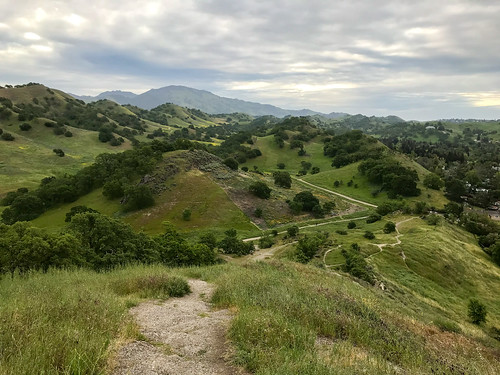
Anyway, I was off, into the first of five different park jurisdictions I would pass through that day. I intended to explore the area, which I'd never visited before, and go up some of the various hills and rock features, and ultimately make it out to Castle Rock, a massive and mysterious protrusion at the western edge of Mount Diablo State Park. The Kovar Trail led up and out of what looked like a community garden, up into the oak studded grassy hills that would define the landscape for most of the day's rambling. It was cloudy and cool, perfect hiking weather, and it wasn't much climbing before I could see out above the suburban homes for views of Shell Ridge and Mount Diablo.
 |
| Shell Ridge high point (center right) |
The first elevation destination was Fossil Hill, which doesn't really have a trail up to it, but still an easy walkup. Crowned with small rock outcroppings and some bushes, it provided a vantage point of the immediate area, mostly other low hills. Back down into the valley, there were lots of flowers out, especially these yellow ones. Luckily I'm not allergic to them, because they're everywhere! I followed the Indian Creek Trail through most of the long valley between Shell Ridge and Joaquin Ridge, and it's a nice backstreet alternative to the Briones-Diablo Regional Trail, which is like the hiking freeway through the region. I moved east and then north to check out a feature called Haystack Hill, but the perimeter of it was surrounded by an "electric" fence! It didn't look electrified at all, it looked like it was made out of string. I grew up in the country, and I know what electric fences look like! But maybe they've found a way to make them out of string now. I didn't try my luck invading the boundary of Haystack Hill, and immediately progressed south to the Ridge Top Trail, and took it up to the high point of Shell Ridge, the dominant feature of that area. The summit was mostly grassy, and slightly rocky, with an empty Gatorade bottle thrown in for good measure. The high point of Shell Ridge is at the southeast end of it. The entire Ridgeline can be traversed via the Ridge Top Trail, I should do that sometime.
 |
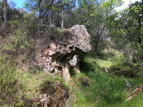
| China Wall formation |
I veered south from that point, through an area of stagnant cattle ponds, and walked around a lightly forested protrusion called Old Man's Hill. I didn't see anything close to a trail going up it on from any side, and in my tired, hungover, paranoid state at the time, I thought the tall grass would be full of ticks, so I didn't go up. But while in the area, I saw a really cool looking pointy hill, which turned out to be accessible from the Stonegate Trail. For the purposes of my writing, I shall call it "Stonegate Hill." (Or "Stoned-Gate", for 4:20?) At the top of this pointy hill, I took my first snack and water break of the day, and diligently checked my socks and lower legs for vampire spiders. From here, I continued southeast, through more open oak meadows, through Castle Rock Regional Recreation Area (which Castle Rock is not even in) to the border of Mount Diablo State Park. At the fence here, I took a hard right and went up along it to the high point of the China Wall area. On the way up, I passed by some fascinating geological features, and a herd of cows that ran away when I got close (Don't worry cows! I don't like beef!) The hilltop was nice, and it turned out to be my major summit achievement of the day, but the real feature of China Wall, from which it gets it name, is just to the east, where a spine of bizarre rock formations undulates linearly up and down the hillsides and through the valley.
Over the wall, my journey now took me on an inefficient S-curve, from Briones-Diablo Road, to the Little Yosemite Trail. One last nasty aside here, this Little Yosemite is the second place in the Bay Area that I've been to that looks NOTHING like Yosemite. Not even a little. So maybe be a bit more careful before you throw that name around? Lil' Yos' took me to Stage Road and a picnic area, where I turned east, along the healthy flowing, and lushly vegetated Pine Creek. An uphill move on the Sunset Trail led up a steep gulch, past some torturous rock formations, signs of things to come at Castle Rock! Excitement was building. But when I topped out at Falcon Road, I was smacked in the face with a sign saying that Castle Rock is closed from February through July each year for the Peregrine Falcon nesting sites! Strangely enough, this was not the first time I had been denied access to a place called Castle Rock due to Peregrine Falcon nesting! So what we learned today is that Peregrine Falcons LOVE castle rocks.
With no reasonable way to proceed, unable to form a loop through Castle Rock as I intended, I was forced to retrace my steps back down the Sunset Trail to Stage Road, where I had a sad snack lunch in the picnic area. I saw that I had approached Castle Rock in the EXACTLY WRONG way so as to miss ALL the signs saying it was closed. At this point, I had already walked thirteen miles from the van, and was hoping I could take a more direct way back! Boosted by a caffeine and sugar laden tea drink, I then hightailed up the Buckeye Ravine Trail, stopping only for a glance back at my failed objective, the majestic Castle Rock formation. After this, I mostly stuck to the Briones-Diablo Freeway, which got me back to the van in just under five miles, much more direct than the circuitous ramblings of the morning. I didn't make it to my main objective for the day, but I saw some other cool stuff, and explored a vast swath of territory I'd never seen before. Not making it to Castle Rock just gives me a reason to return, and it's great to have a reason to come back here.
With no reasonable way to proceed, unable to form a loop through Castle Rock as I intended, I was forced to retrace my steps back down the Sunset Trail to Stage Road, where I had a sad snack lunch in the picnic area. I saw that I had approached Castle Rock in the EXACTLY WRONG way so as to miss ALL the signs saying it was closed. At this point, I had already walked thirteen miles from the van, and was hoping I could take a more direct way back! Boosted by a caffeine and sugar laden tea drink, I then hightailed up the Buckeye Ravine Trail, stopping only for a glance back at my failed objective, the majestic Castle Rock formation. After this, I mostly stuck to the Briones-Diablo Freeway, which got me back to the van in just under five miles, much more direct than the circuitous ramblings of the morning. I didn't make it to my main objective for the day, but I saw some other cool stuff, and explored a vast swath of territory I'd never seen before. Not making it to Castle Rock just gives me a reason to return, and it's great to have a reason to come back here.
ON PEAK NAMES
"Stonegate Hill" I picked this nickname for it because it doesn't have a name on the map, and it's by the Stonegate Trail. To me, it's a hill worthy of a name
China Wall Is this racist by today's standards? Is China Hill cancelled?
FURTHER READING
•East Bay Trails: Information, photos and video of Shell Ridge
•SF Gate: Shell Ridge
•BA Hiker: China Wall and Diablo Foothills Regional Park
•East Bay Hill People: China Wall

No comments:
Post a Comment