

JAMES LICK OBSERVATORY AREA
SANTA CLARA COUNTY, CA
SUMMITS
•Copernicus Peak: 1329m / 4360 ft.
•Tycho Brahe Peak: 1280m / 4200 ft.
PHOTO ALBUM
I was down in San Jose, just before the Coronavirus got really serious. Social distancing was already in affect, but not shelter in place. Or at least I wasn't sheltering in place yet. There had been some pretty heavy weather lately, so Amber offered to give me a ride up to Mount Hamilton to see the snow that had accumulated there. I had never been up to Mount Hamilton in the snow before. I had never been to Mount Hamilton at all! She knew I wanted to visit the place very badly. So we took the long and winding road all the way up, a drive that would have been cumbersome in my giant passenger van, but was a breeze in her nimble Subaru. Past 4,000 feet there was still some snow left on the ground from a storm that had brought only rain to the lowlands. We parked the car and just walked around the area. Due to Covid-19 (or other reasons?) The James Lick Observatory, which normally has visitor hours, was closed. As was the parking lot of Mount Hamilton proper. So I didn't even visit the feature that the whole area is named for. But I had loftier goals in mind. Apparently, the massif which is generally called Mount Hamilton is actually divided into eight sub-peaks, including Mount Hamilton proper (AKA Observatory Peak), and the seven others, all named after astronomers throughout history. The actual highest point of them all is Copernicus Peak, the highest point in the Santa Clara County and the highest point in the nine county Bay Area region. As a "summit oriented" hiker, you can understand why I wanted to visit it so badly. Here are the eight sub-peaks in order from highest to lowest:
1. Copernicus Peak: 4360+
2. Hipparchus Peak: 4240+
3. Kepler Peak: 4240+
4. Mount Hamilton / Observatory Peak: 4213
5. Tycho Brahe
6. Gailleo Peak: 4177
7. Huyghens Peak: 4160+
8. Ptolemy Peak: 4040+
HERE is a map that lays them all out
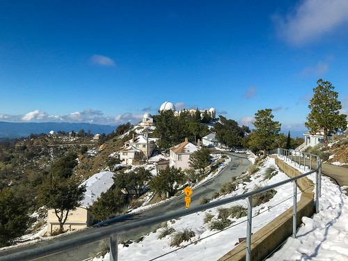
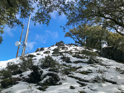
It was a crisp, clear day, and there were good views all around, Mount Isabel to the south, Santa Cruz Mountains to the southwest, and the mysterious private property peaks of the Diablo Range to the north. All in all, I was stoked to finally reach the highest point in the Bay Area, and see the Mount Hamilton area , a self contained astronomer's village within sight of San Jose, but a world apart. In the snow, it felt even more removed from the reality of the valley below, akin to visiting an arctic research station.
Much later in the day, an outing was made to the Calero Creek Trail in San Jose, a few photos of which can be seen here.
FURTHER READING
Bob Burd: Bob tags all the sub peaks of Mount Hamilton
Summitpost: Information On Copernicus Peak
Will Hite Web: Info and pictures of Copernicus Peak
Hiking Project: Information on the Calero Creek Trail
No comments:
Post a Comment