Briones Peaks Loop
 DATE: Wednesday, March 18, 2020
DISTANCE ON FOOT: 11.34 miles
DISTANCE ON BIKE: 3.26 miles
ELEVATION GAIN: 2544
TIME TAKEN ON LOOP HIKE: 4:19 hours
BRIONES REGIONAL PARK
CONTRA COSTA COUNTY, CA
SUMMITS
Briones Peak: 1,483 ft.
Table Top: 1,433 ft.
Mott Peak: 1,424
Russell Peak: 1,357
PHOTO ALBUM
MAP 1
MAP 2
In my perpetual analysis of the green blobs which stud the hinterlands on maps of the Bay Area, Briones Regional Park was a standout. Almost as large as Mount Diablo State Park, apparently, but mysterious. Sprawling. Impenetrable? The darkwild heart of the north-central East Bay. What was in that blob? Cursory research revealed disappointing details: A barren landscape of sunbaked hills, slathered in cow shit and infested with mountain bikers. It did not go to the top of my list. Years passed, and over time, my curiosity grew. Better reports came in of the astounding natural beauty, wild isolation, and if nothing else, fantastic views of Mount Diablo! Of course I would have to visit Briones someday.
Briones Regional Park was once part of Rancho Boca de la Canada de Pinole. In the 1850s and 1860s, the area was developed into rich orchards and vineyards, and cattle ranching was, and still remains, an industry. In 1957 Contra Costa County and the East Bay Municipal Utility District agreed to a land conveyance that established a large open space park in the Bear Creek watershed to be called Briones. In 1964, when portions of Contra Costa County were annexed to the East Bay Regional Park District, the County and the Park District agreed to a transfer of county land to the Park District, with the District to carry out additional land acquisition. Since 1966, watershed lands and other acquisitions have combined to form today’s parkland.
Preferring to always plunge right into the deep end instead of daintily testing the waters, I planned out an almost eleven mile loop excursion through Briones, which would take me to the four named summits within, as well as the only waterfall. To inject additional spice, I decided to make it a carless hike, utilizing BART and bike to get from my doorstep to the trailhead. Here's what I did:
1. Took BART from my home base of MacArthur Station in Oakland to Lafayette Station, three stops to the east. This takes 13 minutes and costs $3.10
2. Rode my bicycle from Lafayette Station up Happy Valley Road to it's intersection with Panorama Drive. 1.36 miles with 174 feet elevation gain.
3. I had to walk my rickety single speed punk bike up the hill of Panorama Drive. If you have a decent road or mountain bike with GEARS, you could probably ride up. It gains 438 feet of elevation in .54 miles. When I got to the park boundary, I locked my bike to a tree, and continued on foot.
4. THE HIKE: 10.8 mile loop through Briones Regional Park.
5. Biking back down Panorama Drive was quite fun, as it's all steep downhill. Functioning brakes recommended. Continuing on Happy Valley back to the BART station is not bad, though the road has no shoulder in some places, forcing you to share the right of way with a steady stream of white BMW SUVs.
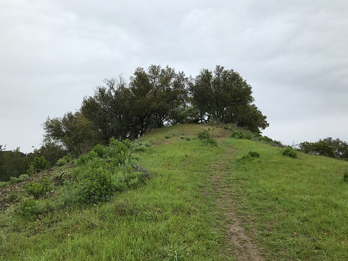
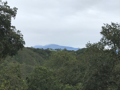
THE HIKE: I locked up my bike and got on with the real hiking part just before 10AM. I intended to start earlier, but I had spent the early morning wrestling with California's unemployment insurance website. But now for the freedom of the trail! The air was cool and the sky was overcast for the entire day, threatening rain, but barely ever following through. I started off on the Mariposa Trail, which is the spur that connects with Lafayette's road system. Mount Diablo immediately peaked out to the east, and the to the south, as I gained elevation, Las Trampas and Rocky Ridge dominated the horizon. Overnight rain and a moist environment had brought the newts out, and I made my first turn, right on to Russell Peak Trail, which led in short order to it's namesake grassy mound. Lafayette Ridge, undulating down to the east, was a striking sight with it's winding trail and emerald green hillsides. To the west, Briones Reservoir shone under the gray skies like a dirty mirror carelessly flung upon a green quilt. Not long after continuing from Russell Peak, I came across a heard of cows blocking the trail. I couldn't believe my eyes, because leading the pack was quite literally the cow from hell. The bovine beasties weren't scared of me, and didn't want to move, and I kind cut around them on the hillside.
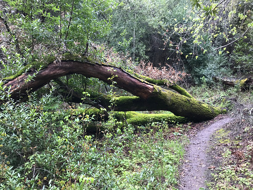
The next trail move was to make an left/east turn on the Seaborg Trail, which had the feel of an old ranch road, and it skirted along a forested tributary of Bear Creek. The best wildlife experience of the day occurred when a screeching hawk flew by. After this I took a left on Bear Creek trail, which crossed the stream, passed by Homestead Valley Campground, and plunged into wildest, or at least wildest seeming area of the park that I saw that day. Bear Creek Trail was the only single track, winding, deeply vegetated trail of the day, and it made me feel like I was in the wilderness, and not on a cow ranch. It led through the woods, to a crossing of Bear Creek, and up some stairs on the embankment of the opposite shore. Down to the right of the steps was a mysterious looking grotto. My illusion of wildness was shattered as I climbed the embankment and emerged into the Oak Grove picnic area, where scattered families walked with their children, and canine companions cavorted without a care.
I crossed through the parking lots of the picnic area and entered the gate for the Abrigo Valley Trail, which was to lead me towards my only non summit destination of the day, Abrigo Falls. Abrigo, apparently is one of those California waterfalls that only exists under the best conditions, and today, even with a few days of rain earlier in the week, and some overnight showers, those conditions were not met. The waterfall I spied through the trees had all the force of a leaky faucet, so I didn't bother scrambling down to have a better look. From here I climbed a rather steep, and extremely muddy trail to the junction with Briones Crest Trail, which was the beginning of a stretch that kept me on top of open, windy, grassy, highlands for for the next hour or so. At this point I got my one and only view out to the northeast, towards Suisun Bay and The Delta. One good thing that can be said for hiking in a cattle ranch is that it's not difficult to travel off the official trails. There are faded farm roads and cow paths going along most of the fences, and even when there's no trail at all, the grass is kept clipped like a lawn by the munching hoards. No bushwhacking required. I was able to use these methods, combined with one barbed wire fence crossing, to easily access Mott Peak, the second summit of the day. King Diablo was eminently visible to the east, and the hills of Oakland and Berkeley crowned the horizon to the west. I cut along fence line cow trails and rejoined Briones Crest Trail at it's junction with Old Briones Road.
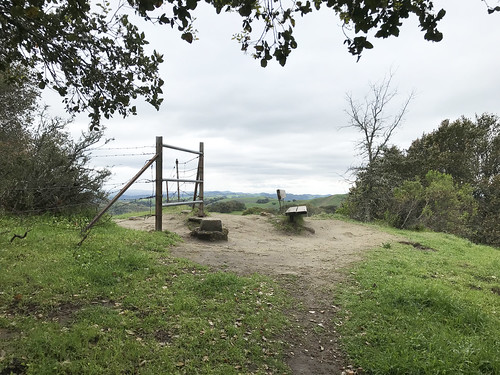
Continuing southeast on Briones Crest Trail, I soon came to an offshoot track that led up to the third (and highest) summit of the day, Briones Peak. It was crowned by both a benchmark, and a bench, and bisected with barbed wire. Just after coming down from the penultimate mound of Briones Regional Preserve, I took the Tabletop Trail branching off slightly to the southeast. Along the way there was a bench, with a plaque dedicated to two brother and sister musician / hikers, who both lived to ripe old ages. That's a good sign for me, if being a musician hiker is good for longevity! Tabeltop, the fourth and final summit of the day, was found soon after, the only one with a building on top. It apparently served some function relating to the minor communications tower there. It's hard to see from this picture, but to the east, there is a very steep hillside, almost approaching cliff status, some of the most extreme topography I saw in Briones.
 |
| Completing the loop |
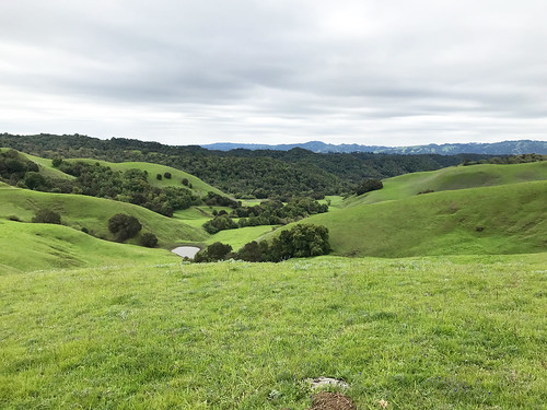
I continued on down the road with the end of my loop in sight, emerald rolling hills to the west. Briones does have it charms, no doubt, as long as you look up and out, not down at the endless varieties of cow pies that litter the thoroughfare. From this section of trail, there was visible an excellent play of light on Diablo's north peak, while the higher south summit remained in the clouds all day. Glad I wasn't up there. I rejoined the Briones Crest Trail temporarily as I got close to my point of origin, and paid some attention to the California Sky Lupines that sprouted alongside. I closed the loop as I returned to the Russel Peak Trail, and then Mariposa Trail, where the same stubborn herd of cattle attempted to block my progress. The final guardians, I had to walk right through them. They backed off a little, and weren't hostile, thankfully. Because if they wanted to, they could have FUCKED ME UP; giant, dumb animals…
Retracing my steps along Mariposa, I found my bike still locked to the tree, and plunged down Panorama Drive in matter of minutes. A few more minutes after that on Happy Valley put me back at the BART station, back in the public transportation system, and at the finale of an extremely epic carless Bay Area hike.
FURTHER READING
•An Ode To Briones by Gambolin Man
•Redwood Hikes (some great photography)
•Norcal Hiker


No comments:
Post a Comment