

DISTANCE: 5.44 MILES
ELEVATION GAIN: 1024 ft.
TIME TAKEN: 2 hours
SUMMIT: Point San Pedro Headland, 620 feet
POINT SAN PEDRO HEADLANDS
SAN MATEO COUNTY, CA
SOUNDTRACK: L7: Slide
PHOTO ALBUM
MAP 1
MAP2
I was traveling solo to meet up with Deathgrave at the Poseidon's Revenge Festival in Pacifica. Most of the gear was backlined, so I didn't have to bring much, or participate in a load in. I knew there were a lot of trails and hills around Pacifica, so I decided to hike up something before the gig. In my minimal research, I settled on exploring Pedro Point Headland, the massive bluff overshadowing Devil's Slide, but didn't exactly know the best way to get there. It being a stunningly beautiful Saturday afternoon on the California coast, there was traffic everywhere, I didn't know where to park, and I got a bit flustered and drove out of town, through the Tom Lantos Tunnel down Highway 1. I decided to walk up the old Devil's Slide Highway, and check that out as well, but the parking lot right by the tunnel was totally full. I drove down the highway to the next parking lot, Gray Whale Cove State Beach, which had some open spots
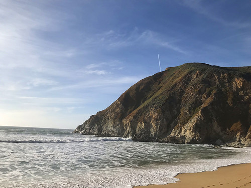
Walking back up along the coast to my destination, I saw a cool looking trail, with a wooden staircase, leading down to the beach. I found it irresistible and went down. It's a really cool beach beneath towering cliffs, and it was pretty crowded. Back up, I continued my march up the road toward's Devil's Slide. Which honestly kind of sucked, even though it was incredibly scenic, because Highway 1 has barely any shoulder in this stretch, and cars were zooming by me within inches! This didn't last too long, and soon enough I was at the entrance to the Old Devil's Slide Highway.
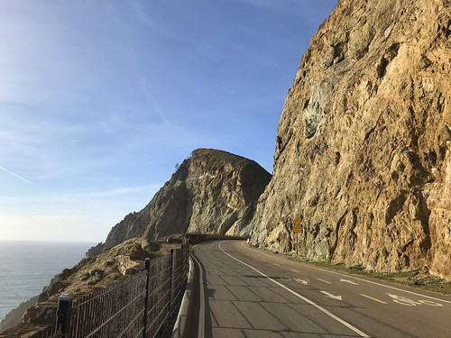
Devil's Slide was the old course of Highway One. Not surprisingly for a place of that name, the old road used to fall into the ocean all the time. So they built a tunnel through the mountain and re-routed the highway through there. But they also retained the old road as a bicycle and pedestrian path, for all to enjoy. Now you you can take a leisurely stroll along this magnificent stretch of coastline, which is exactly what I did. The last time I was on this road is hidden back in the murk of my childhood memories, so it was nice to see it again with my adult eyes, and be able to enjoy it on foot, not from a speeding automobile. There was a mix of hikers, bikers, dog walkers and pram-pushers up and own the road.

Now for my next trick… there didn't seem to be a trail on any map that connected the northwest corner of Devil's Slide Highway to the trail system up in the Pedro Headlands. So it looked like I would have to walk all the way down to new Highway One, and catch the South Ridge Trail at the bottom, losing a lot of elevation, and then have to climb all the way back up again to the headlands. OR perhaps there was an unofficial trail or a not too bad bushwhack that would take me up to my destination. Just after Devil's Slide Highway makes a turn to the east, there's chain link fence with an open gate, and just on the other side of it, a steep use trail goes up the hill. My prayers were answered! It was a loose pebbly track, with brush growing close in, but it served it's purpose and delivered me up at the South Ridge Trail. I had gained sufficient elevation to see out to the east. Turned left on that, and then took the Bluff Trail all the way to the top of Pedro Point Headland. From there, I had a sweeping vista of Pacifica, Montara Mountain, and as far north as San Francisco and Mount Tamalpais. I feel like I'm running out of descriptive words at this point to describe the magnificence of the California coast, so just have a look at the photographs and think of your own.

I was hoping to find a different way to get back to my point of origin, and I investigated, on my phone, what looked like a fire road on satellite imagery, and google maps had labeled as a trail, branching uphill on the south side of of Old Devil's Slide Highway, but it was blocked off by a very intense locked gate, so I had to retrace my steps down the road. Probably better to get back sooner than later anyway, It was time get to the gig at Winter's Tavern. And I returned back, past the coastal cliffs and waning golden sunlight, back along the no-shoulder treachery of the highway, and back to the van. At Winter's Tavern that night, it was a fun gig and a great party, with lots of free food and bands. We were even hooked up with a hotel room in Pacifica so we didn't have to drive home after the show!
FURTHER READING
•Bay Area Hiker: Devil's Slide
•Hiking Project: Pedro Point Headlands
FURTHER READING
•Bay Area Hiker: Devil's Slide
•Hiking Project: Pedro Point Headlands

No comments:
Post a Comment