

DISTANCE: 11.9 miles
ELEVATION GAIN: 3500 ft.(+-)
TIME TAKEN: 7 HOURS
MOUNT DIABLO STATE PARK
CONTRA COSTA COUNTY, CA
SOUNDTRACK: ZZ Top: El Diablo
SUMMITS
MOUNT DIABLO NORTH PEAK: 3849 ft.
BALD KNOB: 2645 ft.
EAGLE PEAK: 2369 ft.
TWIN PEAKS: 1733 ft.
MITCHELL ROCK: 1080 ft.
MOUNT DIABLO CLIMBED AGAIN 1/1/2020
I hadn't been to the top of Mount Diablo since the 80s, when I was a wee lad, and my parents had driven us to the top. I do not remember this. I take their word for it, and ever since moving to California in 1990, the specter of the shadowy mountain has lurked at the edge of my consciousness, the edge of my imagination. It was visible right out the front door, 70 miles away, from where I grew up in Jackson, CA. The fiery California sun would set the horizon ablaze most evenings, Diablo a silent, waiting tombstone for the Helios grave. When I moved to Oakland in 2000, the El Diably was much closer, but much less visible, barely thought of. Only on stoner trips to the highest ridges, and journeys out of town, past the forbidden zone beyond the Caldecott Tunnel, did it rear it massive head. Centrally prominent in the middle of the East Bay population center, yet mysterious to most. A thieves thicket of winding paths, dead end canyons, dark peaks and tortured rock formations. Why did I wait so long to return to Mount Diablo? Well, why did I wait so long to do A LOT of things? Answer me that. I won't like the answer. A whimsical drinking picnic to Rock City in late 2017 was not even an appetizer, it was a midday snack. But it was sometime in 2018 when I made it my goal to hike every major peak in the Bay Area from base to summit, the hardest way possible. I wanted to FEEL the size of each mountain. And Mount Diablo is one of the major-ist of the major peaks around, so it had to be done.
Then the right time came. Tuesday, February 5, 2019. I had the whole day off of work and it was one of those magical rare times when Mount Diablo gets a powdering of snow, so I set out from home as early as I could manage to make my pilgrimage the (temporarily) silver mountain! Popping out of Caldecott Tunnel and pushing East, I could see that the upper slopes of Diablo were graced with snow! But the summit it's self was shrouded in clouds. I hoped they would blow away before I reached the top! But there were many hours for that to happen. Cruised out through the suburban environs of Walnut Creek and up Ygnacio Valley road. Hit a CVS or something for water and snacks.
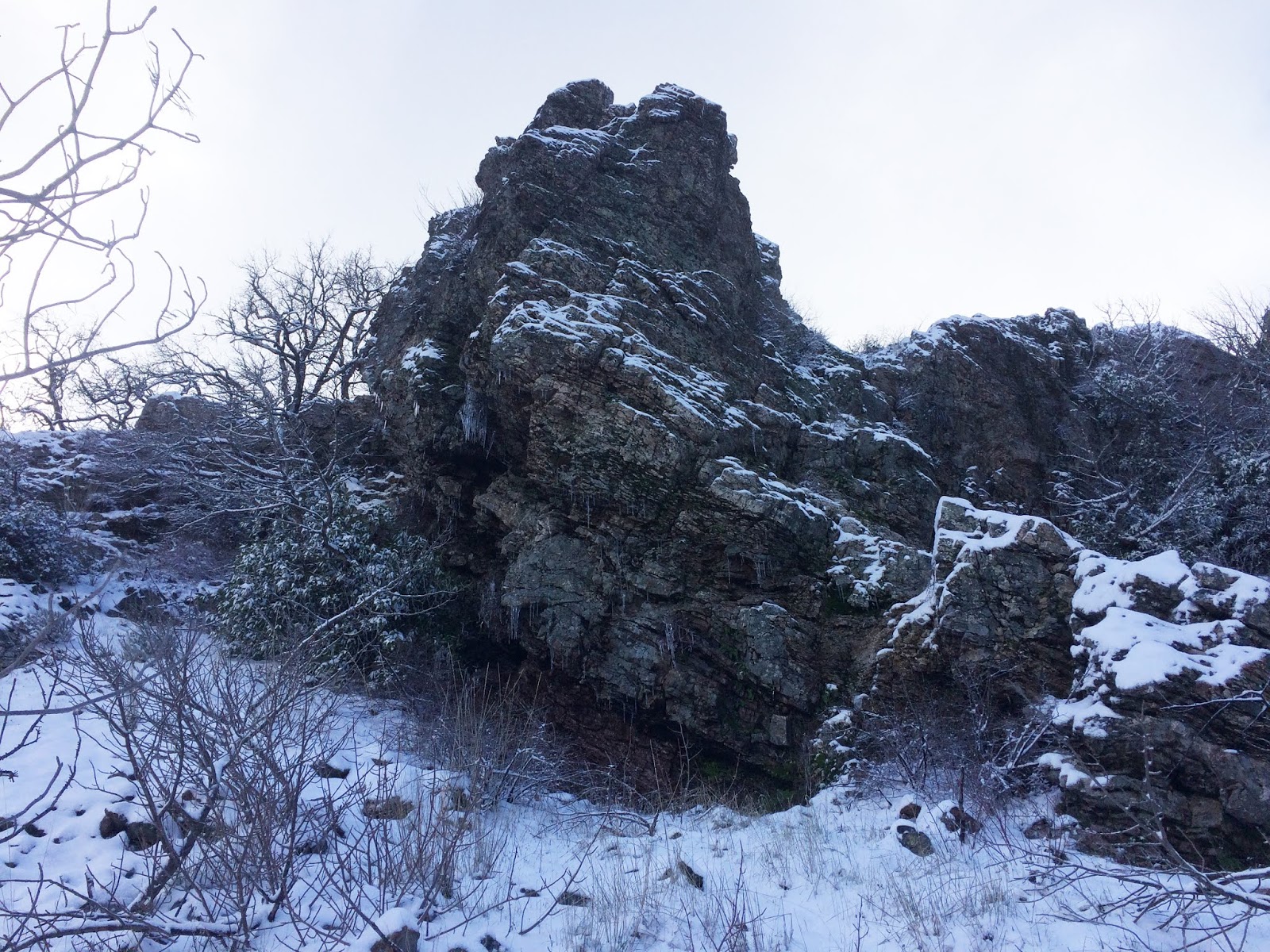
With the added enticement of heavenly dandruff upon the shoulders of the giant, I began my journey from the Mitchell Canyon parking lot. To me this seemed like a suitable jumping off point that I could call "the bottom" of the mountain. Wanting to make up for my years overdue absence from the sleeping behemoth in the Bay Area's backyard, I planned an ASS KICKING agenda for the day, one that would take me all the way to the summit, as well as to several sub peaks and minor attractions. The muddy roads and dog walk domain of the lower regions gave way quickly as I hit the Mitchell Rock trail and began climbing. Sweet ascent. It wan't too long before I had sweeping views to the North, of the canyon I had come up out of, and the ziggurat hillside of the nearby quarry. I could now see clearly how much snow had fallen on the upper heights, and it wasn't too long before I came across my first light patch of the white fluffy stuff, so rare to see in the Bay Area! Mitchell rock was an elementary scramble up to a raptor's perch, with a straight shot looking North down the valley. To the south, I caught a view of the various heights that awaited.

Now for the fun part. I had spent too long at the top. I had chosen a steep and circuitous route to get there. I was tired. As I dragged my ass back down the North Peak trail to Prospector's Gap, I decided to forgo my original master plan of also conquering the North Summit. That would wait for another day. As would the waterfalls. I decided to take the most direct path back to my point of origin. Even without the additional summit second entree, and waterfall side dish, I still had a five and a half mile downhill hike to complete my grand loop dinner, pay for the meal, and hopefully have enough left over for a tip. Stumbling on the steep ramp of Prospector's Gap Road, a fire trail for rugged vehicles. It's hard on the feet walking down a road like that. Middle Trail cut through the bush again to re-emerge at a different part of Meridian Ridge Road, my old nemesis. Nothing but wide and bloody muddy fire roads at this point, I pressed on North through Donner Canyon, the road which mostly parallels a sloshing friendly creek of the same name, and some old time settlement ruins that I didn't have the energy to inspect. Cut West across Murchio Road towards where the van was parked, there's and old water tower out there, and the landscape is back to the rolling, oak studded savanna that probably defines the majority of Northern California. Back in the Mitchell Canyon parking lot, I sighed, scraped some mud from my boots, and fired up the 5.9 litre V8 of my 2000 Dodge Ram Van 3500. It is incredibly wasteful of gas to drive this beast solo out to trail heads. It's meant for hauling the entire band and gear. Oh well. Back to Oakland. Park the damn thing. BART to San Francisco. Hazzard's Cure practice. Late night super veggie burrito from Taqueria San Jose. Just remember: you don't have tot eat the whole thing… burritos are easy to save half for later… you don't have to eat the whole thing… burritos are…

CLICK "READ MORE" TO SEE ADDITIONAL PHOTOGRAPHY


No comments:
Post a Comment