

Distance: 19.5 km / 12.1 miles
Elevation Gain: 843m / 2,766 ft.
Time: 3:47
Summit: El Sombroso 914 m / 2,999 ft.
Sierra Azul Open Space Preserve
Santa Clara County, CA
Soundtrack: T.S.O.L.: Beneath The Shadows
PHOTO ALBUM
MAP
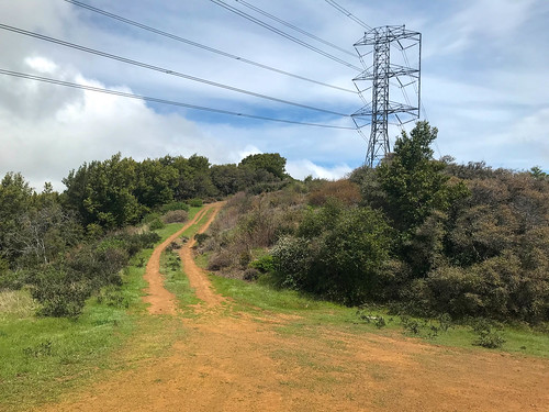
El Sombroso is a high point on the front ridge of the Santa Cruz Mountains. Looking from the north, as I usually do, it tends to disappear in front of the larger Mount Umunhum, but you can see it if you know where to look. It’s not known as a very nice hike: steep, unshaded fire roads, up to a summit who’s main feature is a run of high tension power lines.
I was still in San Jose, but Amber was busy today, so I did my third South San Jose Hills hike alone, which was fine, because I did this one as something of a speed run. Unceremoniously dumped at the Kennedy Trail head just before noon, I asked to be picked up in four hours. This would leave no time for screwing around on the twelve mile hike. The fire road / “trail” meandered upward through a landscape of wildflowers, oaks and brush. The wideness of the road kept it only partially shaded, as did the patchy cloud cover. I hiked fast, because the landscape didn’t change much, and there weren’t too many views out into the valley, or natural features of note, therefore no reason to stop and take pictures every five minutes like I usually do. One notable exception was an extremely majestic mature oak that had been left growing right in the middle of the road. I was at the junction with Priest Rock Trail in just over an hour. I kept on the Kennedy “Trail,” which was now undulating along a ridgeline, south-west toward El Sombroso, slippery gravel bits to be avoided on the down hills parts.

Mount Umunhum was now coming into view, wreathed in strands of coastal fog. After about an hour and forty five minutes after starting out, I had reached the intersection with the Limekiln Trail, and soon after that, the Sombroso summit was in sight. There is a big set of power lines running right over the top of it. The arrogance of man’s attempts to dominate, control and diminish nature will never cease to amaze and offend me. I mean, I use electricity, I like electricity, I know we need power lines, I get it. But put them somewhere else! It was probably the shortest line from point A to point B, over the mountain, and unlike roads, they don’t have to worry about the steepness of the grade, but like I said, oh, the arrogance… rant completed.
I got to the crest of the road, and then crawled several yards into the bushes, north-east, to reach the true summit of El Sombroso. Crawling back out, I contemplated: the best part of the hike? Probably the excellent view of Mount Umunhum. I could also see out across the Santa Clara valley in certain spots, but it was a bit hazy / cloudy. It had taken me almost exactly two hours to reach the top, and it took a little less than that to get down, because, unusually, I jogged some of the downhill. I am definitely not a speed hiker, so this one was kind of an anomaly, one of the quickest hikes on my resume, averaging over three miles per hour.
FURTHER READING
•Alltrails: This is same as the hike I did
•Bob Burd: Bob incidentally hits Sombroso on the way to Umunhum
ON PEAK NAMES
El Sombroso: "The Shadowy"

No comments:
Post a Comment