DATE: Saturday, December 21, 2019
DISTANCE: 12.49 miles
ELEVATION GAIN: 3172 ft.
TIME TAKEN: 5:07
LAS TRAMPAS REGIONAL WILDERNESS
ALAMEDA COUNTY, CA
CONTRA COSTA COUNTY, CA
SUMMITS
LAS TRAMPAS PEAK: 1827 ft.
VAIL PEAK: 1787 ft.
ROCKY RIDGE HIGH POINT: 2024 ft.
PHOTO ALBUM HERE

Las Trampas Regional Preserve is 5,778 acres of wilderness near the East Bay towns of Dublin, San Ramon and Moraga. It's main topographical feature is two parallel ridges, trending northwest-southeast: Las Trampas Ridge and Rocky Ridge, separated by Bollinger Canyon. Rocky Ridge, with a high point of 2024 feet, has the distinction of being the highest point in the North-East Bay outside of the Mount Diablo massif. I had seen it over the years, poking out above the crest of the Oakland Hills, and wondered what it was. Las Trampas is Spanish for "The Traps" or "The Snares." According to
Erwin G. Gudde's California Place Names, traps were once set in the
chaparral of the hills to catch elk. I had never been to Las Trampas before, and I was intrigued by it's wild and rocky appearance, compared to the cow field walks of most other parks in the area. A large network of trails snaked for miles throughout, and I planned my visit with a loop that would take me to all the highest points.
It was the winter solstice, and I had planned to go on a hike with my brother Alex, but based on a text I had received from him at about 4am, I assumed he would probably be in no condition to meet me, so I decided to continue on my own. I don't think I even got started until 10AM or later... it was not early. I drove the van from Oakland to the main staging area in the middle of the park, which was central to everything I wanted to do. It was a Saturday, so it was far from abandoned, but I didn't have to go far from the
trailheads to escape the masses of humanity.
 |
| Las Trampas Ridge |
I began my twelve and a half mile walk throughout the park on the south side of the Bollinger Creek
world of oak (regular and poison), Bay Laurel, and the riparian habitat of the
streambed. It wasn't too long before I gained some elevation, got out of the trees, and was able able to have a look back south, down
Bollinger Canyon. One I got up to the
Las Trampas Ridge Trail, I followed it northwest, where it basically clung to the top of the
undulating crest. Landscape changed to scrub chaparral, and the fire road / trail roller-coastered along the top of the ridge to the eventual high point,
Las Trampas Peak, at the north
-west corner of the park.
Mount Diablo was now clearly visible to the east, and a murky haze filled the valley below, out to Concord and
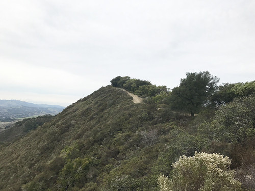
beyond. The top of Las Trampas Peak was a patch of dirt next to an oak tree, a nice place for a picnic perhaps, under different circumstances. The
view southeast along the the ridge top looked too wild to be anywhere close to the middle of the East Bay suburbs, and the other rugged high points of the ridge were in plain sight.
Rocky Ridge, my goal for the second half of the hike, was openly visible to the west.
Loop, which got me immediately into the damp, earthy
 |
| Bridge on Mahogany Trail |
I frolicked back down the Las Trampas Ridge Trail, towards the pointy looking peaks that had captured my attention.
Vail Peak and Eagle Peak. The woody trail dove down into the
vegetation, through mature oak and madrone, and
Vail Peak was a short side trip up a slippery, brushy hillside. By the time I realized that I should have taken a left on the Corduroy Hills Trail to reach Eagle Peak, I was already so far past that I didn't feel like doubling back. I guess I'll save that one for another day. I charged south
-east on the Chamise Trail, which led down a ravine past some
gnarly rock protrusions, and then back into the woods on the Mahogany Trail, which fell quickly under the spell of
arched oaks along the streamed, and carried me over a most picturesque
stream bed. Soon after this, I made a brief return to civilization, such that it is, and temporarily joined Bollinger Canyon Road, a real car road, to continue my large loop. This led near the horse stables and equestrian staging area, aromatic with a tang of dung and straw.
 |
| Attaining Rocky Ridge |
I left the road at my earliest opportunity, plunging back into the bush on the Elderberry Trail, which led
Rocky Ridge, parallel to but, much different in landscape than it's sister ridge, Las Trampas. Rocky Ridge lived up to it's name, and it had enough prominence that I could
now see San Francisco Bay to the west, illuminated by the sleepy winter solstice sun. Coming from this direction, I first reached the southern highpoint of Rocky Ridge, which is 1,877 feet elevation, and has an
EBMUD benchmark. There's also a park bench up there, upon which I took short break, indulging in water and trail mix. At this point, I could have had a hell of an easier day if I had just remained on Rocky Ridge Trail, and followed the crest north-west. But, like a cat that's easily distracted by a shiny thing, I saw a sign for
Devil's Hole Trail (Cool!), and just couldn't resist. So down I went, losing all that hard earned elevation, through a landscape of mostly grassy,
somewhat rocky hillsides. It was not blatantly apparent what Devil's Hole was, but maybe it was
THIS formation. It was a a scenic detour to be sure, and there were more of the Las Trampas Ridge style
brushy, pointy hills to be admired. I took a wrong turn at the bottom, and ended up at the south west corner of the park, at a
boundary gate. It was pretty deeply vegetated down there, and dark, and then I startled a herd of what was probably wild pigs… the animals ran off quickly through the bush I couldn't get a good look at them.
first gently, and soon steeply, up to the long crest of
 |
| West to a solstice sunset |
Back out and up. Time to pay for my visit to Devil's Hole (no one goes for free) with some punishing elevation gain to regain Rocky Ridge, up the Sycamore Trail. To the west, I was able to identify
Ramage Peak. And beyond, the undulating series of ridges that stack up behind
San Leandro, The Bay glimmering in the distance. Maybe the Sycamore Trail is punishingly steep, maybe I was running out of steam at the end of the day, maybe both. But
the landscape is worth it, I would consider this the "dark" side of Rocky Ridge. Rocky, pointy little peaks, no other humans in sight. A good push got me back up on top of
the ridge, and I continued to the high point, labeled as "Rock 2" on the map, at 2024 feet.
Good views of The Bay at this point. Personal energy and sunlight were low by now, so I hightailed down the hill back to the parking lot, on a semi paved road. And now, I'm low on words to say, so if you want more, try these!
FURTHER READING•
•BA Hiker "Las Trampas Regional Wilderness is the tough guy of the East Bay Regional Park District."
•Redwood Hikes (nice, big photographs)
•KQED (good notes on geology)


No comments:
Post a Comment