Showing posts with label Alpine County. Show all posts

Monday, July 27, 2020

Red Lake Peak

DATE: Monday, July 27, 2020
DISTANCE: 25.1km / 15.6 miles
ELEVATION GAIN: 1,245m / 4,085’
TIME TAKEN: 9 hours
ELDORADO NATIONAL FOREST
HUMBOLDT TOIYABE NATIONAL FOREST
ALPINE COUNTY, CA
ELDORADO COUNTY, CA
SOUNDTRACK:
Shrine Of The Serpent: King In Red

SUMMITS:
• Red Lake Peak: 3067m / 10,063’
• Crater Lake Peak: 2972m / 9,750’
• Stevens Peak: 3066m / 10,059’
• Peak 9,442’ / 2878m
• Peak 9,211’ / 2808m
• Peak 8665’ / 2641m


PHOTO ALBUM
MAP


…continued.

I had been out trying to hit the summits and trails in the Sierras for five days, and on the sixth day, I finally got the early start I’d hoped for every time. Up at 5:30, barely anything to clean up at camp, up the road to the Meiss / Pacific Crest Trailhead at Carson Pass, a quick brekky out the back of the van, and I was off at 6:30AM. There’s an unofficial trail that goes up to Red Lake Peak, from the parking lot, which I didn’t find at first, because I walked the wrong way out of the parking lot. I circled back a little, over the rocks and found the trail, which I was able to follow all the rest of the way to the top, through the alpine brush and volcanic outcroppings. The sun had now just come up, and Red Lake, below, was shining like a mirror. To the south, majestic morning light illuminated the massif from Elephants Back to Round Top to The Sisters, and on to Caples Lake. For an unofficial trail, this one was very strong, and I was making good progress. It wasn’t long before i gained enough elevation to see my first view of Lake Tahoe.

When I got up to the top, my first stop was the southern “prow” that looked out over Carson Pass. But this was not the summit. To the north was was an ominous series of of igneous extrusive columns. According to GPS, the south one was the high point, so I climbed it, fun class 3, this volcanic rock ain’t so bad as long as it’s not falling apart! In fact, it can be really good, with the chunky formations in the conglomerate rock forming handholds. From the top of the “summit,” the next formation looked taller, so I climbed that one too, just to be sure. I had a good view of my adventures from a few days back: Raymond Peak and Silver Peak in the distance beyond. I had felt very tired when I first started out, and I thought maybe I would do RLP only, but by now I was feeling invigorated, and decided to continue along the ridge, following my original master plan. Though it is not on any map, there is a solid trail from RLP all the way to the base of Peak 9211, and beyond. The trail would come on really strong sometimes, and then suddenly disappear. Then, as I continued cross country, I would meet the trail again, as it came in from another direction, and I would be like “where the fuck have you been?”

I crossed Crater Lake Peak, and hopefully it’s summit, it’s a pretty flat mound, and from there I took a look down at the whimsically named lake from which the “peak” takes it’s name. Moving on from there, I was on top of Stevens Peak by 9:20AM. More distinctive than Crater Lake Peak, it had class 2 sharp rock piles on top, and a great view of the organ pipe volcanic cliffs / columns that fell below Peak 9442’. Back on the main ridge, after Stevens Peak, I shed some of the extra layers of clothing, because it was warming up, approaching 10AM. Continuing north, I must have crossed Peak 9442’, because I was sticking to the ridgeline, but I barely noticed it. By 10:40AM, I broke off my relationship with the fickle use trail, and headed up to Peak 9211, going north-west now to do my big loop.  The trail seemed to continue it’s own way, to the north-east, probably to Waterhouse Peak.

There was a standard rocky outcrop to crown Peak 9211, but a surprise when an adorable fawn erupted from the bushes and bounded away, followed moments later by a second one. then I glanced downhill saw a Marmot! This must be the wildlife section of the hike. Down the hill I went, headed for cross country uncharted territory. West off of Peak 9211’ was brushy, so I headed for the pines, and followed them down to a bubbly little creek. Up the other side of the ravine, I was aiming for Peak 8665, but my aim was off, and I went too much due west, I should have cut north-west to the saddle, I could have saved myself some elevation gain and loss. During this time, I crossed a mysterious old trail, but didn't follow it. Before I got to my summit destination, I reached the top of the rocky cliffs that rise above Round Lake. Following the cliff edge north, there was an excellent view down at the lake. The top of Peak 8665 had a cairn with a stick poking out like a flagpole, the only marker of any kind that I saw on any of the peaks that day. North-northwest down the ridge now, through light forest. I reached the Meiss / Tahoe Rim Trail in a half hour, the first official trail I’d been on all day, followed immediately by the first other hikers I’d seen all day. Around the next bend, to my surprise, I came upon a gentleman playing flamenco guitar. He was good! I felt like I was in Disneyland now, entertainment provided.

Just after 12:30PM, I was at the shore of Round Lake. There were a few scattered camps of people around. I decided to circle the lake around the west side, so I could take in the view of the towering cliffs above. There is a pretty strong use trail around (most of) the west side, but I made it more difficult for myself by intentionally avoiding all the camps of people. I stopped briefly to dunk my feet and take a break at one isolated spot I found. The use trail dissipated by the time I reached the southwest corner of the lake, and there was some pretty bad swamp / bushes / alpine jungle. I had to backtrack a little, and try a few different options before I got through, but I did it without too much real bushwhacking. Shortly after that, I rejoined the main trail near the southeast corner of the lake. Now, with no more peaks to climb, and no more lakes to circumambulate, I picked up the pace. Through the woods, then across pastoral Meiss Meadow to hit the PCT in less than an hour. I had a good view to the east of Carson Ridge, the four peaks I had climbed across in the morning. there were a few hikers around, and an especially big group crossing a creek near the trail junction. They paused to let me pass by. Back in Oakland I don’t look like a very threatening person, but on the trails, i must look some kind of savage barbarian bandit, because the yuppies, Girl Scouts, and retirees give me a lot of space. More easy undulating terrain, one more hour on the PCT, and I was back at the van at 3:42PM. I drank my last beer, and drove back to my parents’ house down in Jackson.

FURTHER READING
• Tahoe Trail Guide: A different approach to  RLP
• Outdoor Project: A little history on RLP
• Bob Burd: Bob on Red Lake Peak
• Red Lake Peak on SUMMITPOST and PEAKBAGGER
• Crater Lake Peak on PEAKBAGGER
• Stevens Peak on SUMMITPOST and PEAKBAGGER
• Peak 9,442 on PEAKBAGGER
• Peak 9,211 on PEAKBAGGER
• Peak 8665 on PEAKBAGGER


Sunday, July 26, 2020

Black Butte 9031'

DATE: Sunday, July 26, 2020
DISTANCE: 4.1km / 3.55. iles
ELEVATION GAIN: 260m / 853’
TIME TAKEN: 1:15
SUMMIT: Black Butte Second Spire
ELDORADO NATIONAL FOREST
ALPINE COUNTY, CA
SOUNDTRACK:
AC/DC: Thunderstruck

PHOTO ALBUM
MAP


...continued.


The first time I woke up, it was 4AM, and I should have gotten up and headed straight for a trailhead, but I was in a luxurious bliss, in a camping van with a very nice bed, much more comfortable than the primitive arrangement in my apartment. So I unfortunately fell back asleep until 8AM or so. I had a simple breakfast, and then helped break down Kyburz Camp. The others were headed for San Jose and San Francisco, and I took off alone, up Silver Fork Road, all the way through to Highway 88, a way I’ve never gone before. Reviewing my to-do list for places to hike, every trailhead I passed by was slammed over capacity with cars. I thought maybe some people would be going home by Sunday. I decided to check out Woods Lake Campground, the jumping off point for the beloved Round Top hikes of childhood, and see if I could get a campsite. I got one, and then realized, if I was gonna stay another night, I would have to get more food! So I drove out to the Kirkwood general store, better sooner than later I figured. During my brief window of cellular reception, I saw that thunderstorms were predicted from 3-4PM. Back at Woods Lake, diligently depositing my goods in the bear box, I figured I could get in a quick trip to Black Butte before the storms hit. Wrong.

I saw the black clouds coming in, and soon after, heard the first crack of thunder. I decided to hang at my lovely campsite and wait it out, updating my very outdated hiking journal notebook, and doing some reading as well. Then the rain began, so I put everything away and jumped into the van. Thunder and rain came hard, and I decided to curl up on the bench seat of the van, in the sleeping bag, and just enjoy it. I reached a state of total tranquility  there, holed up in the van pod, pouring rain on the roof, and some of the loudest thunderbursts I’d ever heard, just overhead. I drifted into a nap and woke up about 7PM. It was still overcast, but the storm had passed. It was time to hike! I went out directly west from the campsite, cross country, meandering through pine and scattered rock, up and over a small granite hill, I could now see Black Butte, a volcanic dinosaur back ridge going north-south. It was still plenty light out, so I continued, across more granite, an alpine meadow, and finally the ascent of the volcanic meatball sauce rock of Black Butte. 

I directed myself towards what I thought was the highest part of the formation. I topped out, and had a stupendous view of the sunset over Caples Lake. But from here I also saw that the high point was actually the next crag to the south, lobe of savage volcanic treachery. I looked to see if I could downclimb the chasm that separated my location from the desired high point, but it looked too tricky, even if I had full daylight. I would have to retrace my steps back down the east side and then ascend again the higher spire. By the time I got back down, ti was getting too dark to do another climb, so I decided to go back to camp. I went back across a damp meadow, around instead of over the granite ridge, and then hit a surprise dirt road that carried me all the way back down to the campground. It was such a solid, broad pathway that I never had to turn on my flashlight, though it was well past sunset now. Now, to savor the delights of a cold, dark, wet campsite, I had hotdog buns with Kraft medium cheddar cheese, from the Kirkwood store, garnished with dill relish and mustard, washed down with Chico’s finest. i listened in the dark like a wraith, to the merriements of the other campers that surrounded me, the cries of their children. Tomorrow would be one last hike before I went home, somewhere in the Carson Pass area. I flipped a coin to make a choice: tails for Emigrant Lake, and heads for Red (Lake Peak), and it was heads for red.

To be continued…

FURTHER READING
• Fedak:
Good info on how to properly reach the highest point
•Bob Burd: Bob takes on Black Butte
• Black Butte on SUMMITPOST and PEAKBAGGER


Thursday, July 23, 2020

Silver Peak

DATE: Thursday, July 23, 2020
DISTANCE: 17.2km / 10.69 miles
ELEVATION GAIN: 1,292m / 4,238’
TIME TAKEN: 11:10
HUMBOLDT TOIYABE NATIONAL FOREST
CARSON ICEBURG WILDERNESS
ALPINE COUNTY, CA

SOUNDTRACK: Rainbow: Man On The Sliver Mountain

SUMMITS:

•Silver Peak SW Summit 3,283m / 10,772’
•Silver Peak NE Summit 3,292m / 10,800’


PHOTO ALBUM
MAP


...continued.

Silver Peak is one of two sets of striking double peaks (the other being Highland) that form a massif just south-east of Ebbetts Pass in Alpine County, CA. I was poised at Silver Creek Campground in a bid to climb them both (and maybe even Tryon Peak as well). I would simply walk to the Noble Canyon Trail, right from my campsite, and begin from there. Climbing up Silver, Traversing the ridge to Highland, coming down to take a dip in Noble Lake, and heading back to camp along the well established trail. It would be spectacular. Nothing could go wrong!

Due to getting crap sleep in my tent, I didn’t wake up until 7:30AM, much later than I intended. I hesitated to rise, feeling the burn in my body from yesterday’s sixteen miles on the trail. Slowly, I dragged myself out, had a simple breakfast, and got ready to go. I left the campground at 9am, hiking out on a nameless trail that goes out of campsite 15, up to the hairpin turn in Highway 4 where a more official connector trail begins. Granite and volcanic rock formations came into sight almost immediately, followed by the the Silver-Highland complex, and then a fine alpine meadow. There was a clear signpost where my path intersected the official Noble Canyon Trail, and I continued south on that, over a primitive bridge on the namesake creek, and then on through the woods. At 9:54, I turned left off of the trail, heading cross country, based on a GPS of Bob Burd’s route of ascent. Side creek waterfalls were active, and volcanic rock scenery kept things interesting. I came across ghost trails here and there, that would appear and disappear, footsteps in the dirt, and then nothing. I followed them as best I could, because they seemed to be going in the right direction, but they always evaporated.

By this point, I had gained some elevation, and had views out back west to Raymond, Reynolds, and The Sinister, yesterday's playground. Now faced with a massive field of open brush in front of me, I changed course, and went for a gully with pine trees on one side, and talus chaos on the other, making my way uphill with rock hopping, just on the edge of the woods. After the top of the gully, the rocks got steeper, and volcanic sentinels erupted from the slope, frowning down at me, begrudgingly allowing my passage. So far, I had felt I was doing pretty good on the elevation gain, having slept at 7,000 feet the night before, and having gotten more rest than the previous night. This good feeling soon crumbled away like so much talus as I approached the peak, I was just as tired and out of breath as I had been yesterday on the steep part, pausing about every 20 steps. I invented switchbacks as I went up, zigzagging towards the sky. It was 1PM when I finally dragged my body over the top of the ridge, four hours ascent. Now I over the top, I could see the storm clouds coming in from the south, already engulfing highland peak, I quickly tagged the lower, southwestern summit of Silver, which I had come up right by, and then began crossing the ridgetop to the higher northeast summit. I could hear cracks of thunder getting closer. This was not great. They say if you can hear the thunder, it’s already too close, and you shouldn’t be out there. Whoops!

Down to the saddle, and up to the high peak. It was good clean rock out there, wish I could have enjoyed it more, but the encroaching storm was stressing me out. On Silver NE, I grabbed the ammo box summit register and dragged it downhill a bit, so I wouldn’t be so exposed. The register box had an old notebook that was rolled up and completely soaked, and a more recent, current one in a ziplock bag, which I signed. I ran the ammo box back up to it’s place on the summit, and got back down again as fast as I could. That’s just when the thunderstorm really hit Silver Peak. Thunder was close, cracking all around me. I started plunging downhill, trying to get off the ridgeline, I was going too fast, sliding on scree and over boulders. I said to myself “you’re panicking, if you don’t slow down, you’re gonna get hurt.” I slowed down. I wanted to get off the mountain ASAP, but I didn’t want to go back over the high top of the ridge where I had come from, and have a bigger risk for getting struck by lightning. In my haste, I had run down the east side of the mountain, away from trails and civilization. I decided to contour south, along the east side, and try to cross back over the ridge at the Silver-Highland saddle, the lowest point. I began moving, and then the first rain drop hit my face. I didn’t mind getting wet, but I didn’t want to get soaked. The storm continued to pick up. I was still at almost 11,000 feet, and the sound of a thunderburst across the mountaintops and through the alpine valleys is like nothing I’ve ever heard, in both volume and profundity. As a longtime fan of loud sounds, it was one for the books.

I decided to find a place to wait out the worst of the storm, which was not abating, and sought shelter in a volcanic crag alcove. I somehow had cell reception coming in from Nevada somewhere, so I sat and read the news about the horrible things going on in the outside world. Then I got bored of the cave, and made a mad dash south to get closer to the saddle, but thunder continued strong, so I took shelter again in another alcove, not as good as the first one. I waited and waited, and the thunder kept coming. Finally, it seemed like awhile since the last thunderclap, so I decided, if there’s not another one for ten minutes, I’m getting out of here. I got out of there. I scrambled over the volcanic formations on the east side of the ridge, still gun shy about returning to the top of the ridge, hoping to find an open path to the saddle, and my descent. I climbed over a nasty crag, and said to myself “please don’t be cliffs on the other side.” There weren’t. There were rocky slopes with scrub pine, and a means of escape. By the time I got to the saddle, it was 4PM, so much time burned hiding out from the storm, but I was now treated to views of gloomy looking Highland Peak along the way, and when I got over the ridge, I saw out to the west, Raymond-Reynolds peaks dusted with snow! In July! The magical view almost made everything worth it.

Now at the saddle, I had invested so much time and effort getting over here, I didn’t want to back up to retrace my ascent path, even though it was a known quantity. I also felt like it was too late in the day at this point to go tackle Highland Peak, and let’s face it, I was kind of “over it” as far as mountain climbing was concerned. I said “fuck it” and dropped straight down, west from where I was at. Dumb idea. It was all downhill, after all, and it was fun at first, boot skiing down the scree slopes. But this was not to last. Bushwhacking, rock sliding, picking my way down the drainages, through muddy mountain springs fields, and on, and on… The going was very slow, not even a deer trail to follow, choosing between one bad option or another. No country for human beings. I was scratched on the legs, smacked in the face, and fell on my ass more times than I care to recall. Frequent breaks to dump the rocks out of my boots. I ended up following the creek drainage, lots of brush, so many riparian bushes, down into a canyon, a gap in the rocks that looked like a waterfall coming ahead, this was one of the few times I would be happy to NOT see a waterfall ahead. No cliffs too, please. Anyway, no waterfall, no cliffs, but I could see out that I was still high above Noble Canyon, and I would have to keep picking my way down, so many rocky slopes. I was glad there was no chance of people being downhill from me, because I sent so many big rocks rolling as I plunged downward.

It wasn’t until about 6:30PM that I finally got off the slopes. Once in the “privacy” of the woods, I finally dug a hole and took the anxiety shit that had been brewing since the first thunderclap hit. It was easy going now, through the pines of Noble Canyon’s floor, and when I finally got to the trail, I could have gotten down on my hands and knees and kissed the packed dirt. But I didn’t. It was now easy going south along what felt like a superhighway. Noble creek was invigorated by the storm. Pink picturesque sunlight cast upon the peaks to the south. All trail back to camp. Last looks back up at Silver Peak. I had a PB & J sandwich and one beer and passed out at 9:45PM on the bench seat of the van, trying to see if this more familiar sleeping situation would garner me a better quality of rest than the tent, after all, how many nights of excellent sleep have I gotten on van bench seats over the years?

To be continued...


FURTHER READING
Bob Burd: My ascent loosely based on this
Fedak: Another ascent from the west
Marcus Sierra: Another ascent from the west
Silver Peak SW on PEAKBAGGER
Silver Peak NE on PEAKBAGGER


Wednesday, July 22, 2020

Raymond Peak

DATE: Wednesday, July 22, 2020
DISTANCE: 25.81km / 16.04 miles
ELEVATION GAIN: 1250m / 4100’
TIME TAKEN: 10:18
MOKELUMNE WILDERNESS
ALPINE COUNTY, CA

SOUNDTRACK: Autopsy: Twisted Mass Of Burnt Decay

SUMMITS:
•Ebbetts Peak: 2,792m / 9,160’
•Raymond Peak 3,052m / 10,014’


PHOTO ALBUM
MAP


Raymond Peak is the third highest peak in the Mokelumne Wilderness which straddles the Pacific Crest between SR4 (Ebbetts Pass) and SR88 (Carson Pass). The 105,165 acre Wilderness takes in portions of the Toiyabe, Stanislaus, and El Dorado National Forests, and lies in the mid-Sierra region between Lake Tahoe to the north and the High Sierra to the south. The peak lies just east of the Sierra Crest, about six miles north of Ebbetts Pass. The views offered from the summit go north to Freel Peak and Desolation Wilderness, west to Mokelumne Peak (and to the Coast Range on unusual clear days), south to the peaks of Emigrant Wilderness and northern Yosemite, and sweeping east into the Great Basin of Nevada.  -Summitpost


I had spend the previous day working on my van at my parents’ house in Jackson, CA, attempting to rip out the old floor, and put a new one in: I only succeeded at the first part. Then, faced with the choice of leaving for my hike the night before and staying the night at Ebbetts Pass to get an early start the next day, and a little acclimation, or leaving early in the morning so I could see Highway 4 (I had never been past Big Trees on it), I chose leaving in the morning, a choice which was more or less thrust upon me by the amount of drinks had with brother and dad that night!

Up at about 5:30AM, on about 4 hours of sleep, I was on my way. Stopped for gas in Arnold, where there seemed to be “Rednecks Against Mask Wearing” (R.A.M.W.) convention in the parking lot. Kept going, past Big Trees, and into unknown territory, new exotic sites such as Lake Alpine and Cape Horn. I reached Ebbetts Pass after 8AM, and ate my breakfast there. I was hiking by 830AM, across the highway, I thought it would be quickest way to reach Ebbetts Peak (I decided to throw it in as an appetizer, not desert, a wise choice) by avoiding the PCT, and going through the woods right across the road from the turnout. I almost immediately ran into the steep talus slopes below the peak, and (no trail yet), had to cut west to continue. I instantly found a dirt road with a parking lot, and a trail leading up the west side of Ebbetts from there, a well worn footpath in the pile of volcanic rocks. Twenty minutes after leaving the van, I was on top of Ebbetts Peak, where there was an american flag fluttering on a pole, and a register in a box at it’s base, which I signed.

It was actually a good choice to climb Ebbetts at the beginning of the day, because it gave me a lay of the land (S-W-N-NW-E-SE), to see where I would be going today and tomorrow. You usually don’t get to have that chance at the beginning of a hike. Still not knowing much about Ebbetts Peak, I figured I could probably just descend the east side, as a nice shortcut down to the PCT. I scrambled around for too long, looking for a way down, and almost tried descending a nasty chute, before I realized my folly, and went back down the way I came up, to it's west shoulder. Lesson learned. Ebbetts Peak: “JUST STAY ON THE FUCKING TRAIL.” I surfed down a sandy hillside, and then walked through some light woods, finally hitting the PCT at about 9:30AM, having burned most of the first hour fucking around on “warm up” Ebbetts Peak.

The well trodden dirt of the PCT had me picking up speed, finally, and I blew past the Kinney Lake Trail turnoff, intending to take a dip in it later. Right after that, I crossed the wilderness boundary. The PCT took me in a generally northern direction, with the volcanic sub rocks of “Kinney Crag” and Reynolds Peak protruding to my left. It was a beautiful day, not too warm, and flowery meadows abounded on either side of me. I hadn’t forced myself to to decided beforehand if I would climb both Reynolds Peak and Raymond Peak that day. As I passed the turnoff for Reynolds, I decided I would hit Raymond first, and at least obtain the highest peak in the area, and then hit Reynolds on the way back, if I still had the energy. So I kept on hauling ass down the PCT toward Raymond, the Sierra Superhighway beneath my feet. As I got farther north, and had Reynolds Peak rising on my left, the rock formations became more astounding. It was almost national park grade scenery! If didn’t already know better, I would have assumed Reynolds Peak impossible to climb! It was quite the twisted mass of volcanic decay.

Not long after that, possibly the most striking feature of the whole area came into view. Being called by such names over the years as Pennsylvania Crag, Sentinel Peak, and The Cylinder, the still unofficially named feature has, at least on peakbagger.com, become known as “The Sinister,” which is quite agreeable, for obvious reasons. It looks like a burned, smashed and melted cathedral fortress. Quite sinister indeed, I will have to find a way up it someday. About this time, the PCT veered to the east, following the south side of a sub ridge that rises between Eagle Creek and Pennsylvania Creek. Jutting from this intermediary ridge were yet more astounding specimens of volcanic turbulence, the most prominent being a titanic bulk of stone which I eventually nicknamed “Behemoth Rock.” (Moron that later.)

About 2.5 hours after leaving the van, I turned off the PCT again and temporarily followed Pennsylvania Creek west, then began angling north-west, uphill toward Raymond Peak. I’m pretty certain that this is not the easiest way to approach, but it worked. The route was very steep, lots of talus, occasionally using the scrub bushes to help drag myself upward, but there was no tricky rock climbing. Just up and up, through the strange steep world. I found a cave, an animal jawbone, and plenty of cool rock formations to keep me interested. There was now a terrific view of Reynolds back behind me. I began to slow down, I don’t know if it was the lack of sleep, the lack of acclimatization to the elevation or both? It took me about 1hr 45 to climb the 1800 feet from the PCT to the top of the mountain. There was a volcanic summit block area, a keyhole crack view of Round Top, and a summit register which I dutifully signed. I hung around up there for maybe 20 minutes, had a snack, and then began heading southwest down the ridge toward The Sinister. At first I tried to stay on top of the ridge, or close to it, but I kept on getting to shitty cliffs, so I finally went north, down off the ridge, and continued through the trees. I was pretty tired by this point, and wanted to save energy for getting back, so I decided to hike a bit closer to The Sinister, then go back cross country to the PCT and retrace my steps, saving the ascent of Reynolds for a future date.

Just after I had gotten off the summit of Raymond, a thunderstorm had come by, not too close, but I'm glad I wasn’t still up at the top. By 2:45, I came up over the saddle low point between Raymond and Sinister, and that was the closest I got to that ominous black rock. I began descending south, through monstrous rock formations, down a dry canyon that was probably the upper reaches of Pennsylvania Creek. By now I was coming around the other side of the ridge that contained “Behemoth Rock,” and I saw there was more to it than had realized on my way in. It was not a thick chunk of rock, but more of a thin fin, which appeared to have a large opening bored in the north side, resembling an eye? A mouth? A black hole? As I continued my hike, the angle of “Behemoth Rock” kept changing, it looked like a vile creature erupting from the earth, fascinating and obscene at once. In a day of many rocks, it might have been my favorite. During this section of the hike, I also had a good view of the saddle between Reynolds and The Sinister, “The Devil’s Glove,” six fingers of black volcanic rock.

The cross country travel through the area was enjoyable and scenic, rocky hills with rust colored earth exposed, down through some drainages and light pine woods, trying not to gain or lose too much elevation. The end of it came as I descended another small canyon, surprisingly red rocked, this one with a bit of water in it, but not enough to be a problem. After this, I veered east and my cross country travel came to an end as I rejoined the PCT at about 4PM. It was time to stop picking my way through rocks and talus, and start picking up the pace. I stormed south through Raymond Meadows, outpacing the afternoon clouds which drifted lazily across the sky, stopping only to take pictures of the wildflowers. By 5:30, I was at the shore of Upper Kinney Lake. The storm had cooled off the second half of the day, and it was getting late, so it was not as warm as I'd been hoping, so I didn't jump in, but I dutifully inserted my feet. Continuing back south again on the PCT, I was in the shadow of Ebbetts Peak by 6:20, and I was glad I had already climbed it. Although the hike was almost complete, I extended it just a bit more by going out on a granite plateau for photos of Kinney Reservoir, Silver, Highland and Ebbetts peaks. I got back to Highway 4 on the proper trail this time, and then did the short walk along the road to get back to where I had parked, just before 7PM.

So If I was only going to hike Raymond Peak that day, why didn’t I take one of the AT LEAST two easier ways to get to it? Who cares? I enjoyed through the scenery, and it was a fine intro survey of the north side of Ebbetts pass. So then I jumped in the van, and drove 15 minutes down the road to my reserved campsite at Silver Creek.

...to be continued.

FURTHER READING
•Alltrails: This is similar to my approach to Raymond
•Raymond Peak on SUMMITPOST and PEAKBAGGER
•Ebbetts Peak on SUMMITPOST and PEAKBAGGER


Thursday, June 25, 2020

A Name Change For Jeff Davis Peak?

LINK TO CAPRADIO ARTICLE / STREAM HERE

It's hard to find anything to post about in Hiking Metal Maniac that is relevant to the contentious and important current events going on right now, but here's one thing! Jeff Davis Peak, in Alpine County is a striking, steep sided rock formation, which I have been admiring since I was a child. Unfortunately, it turned out to be named after Jefferson Davis, the president of the Confederacy, most likely by sympathetic gold miners who arrived in the area from the South. Since I started writing HMM, I've been thinking a lot about peak names, how they got them, and ones that are problematic, what should they be changed to? I think the default in any situation should be to revert to the Native American name, if it is still known.

A few years ago I looked up internet news to see if there was any effort to change the name of Jeff Davis Peak, and I saw the wheels were already in motion to change it to the Washoe name Da-ek Dow Go-et (A Saddle Between Two Points). Now that the removal of Confederate monuments and places named after slave owners is at the forefront of news, CapRadio released this little update on what's going on with Jeff Davis Peak. And let's face it, in a state with many, many mountains named after dead white guys, slave owners, colonizers, genociders... could you pick a worse one than Jeff Davis? The President of the white supremacist Confederate States; he doesn't even have any historical connection to Alpine County or California. He vehemently opposed the idea of California entering the union, because it would have been a new non-slave state! The fact that it takes MUCH LONGER to change the names of problematic mountains than to tear down problematic statues is discussed in the radio show.

While researching this post, I also learned that another Jeff Davis Peak, in Nevada, is also very close to being renamed to it's Washoe name: Doso Doyabi. Let's keep this going!

Friday, December 27, 2019

Round Top (10,381)

DATE: Friday, December 27, 2019
DISTANCE: 7.36 miles
ELEVATION GAIN: 2074 ft.
TIME TAKEN: 6:12
SUMMIT: 10,381 ft. SPS OGUL
MOKELUMNE WILDERNESS

ALPINE COUNTY, CA


PHOTO ALBUM HERE
Round Top: December 27, 2019


Round Top. This is a mountain that I go way back with. The first Sierra Peak I ever climbed, my first time over 10,000 feet, my first "real" mountain, with exposure, scrambling and a rocky crown. But I realized not too long ago, during this personal surgence in "summit oriented hiking," that I had never made it to the true summit. Two or three visits had been made during childhood, coming up Highway 88 out of Jackson for Sierra Nevada day hike family excursions. It didn't cross my mind until recently whether or not I had made it to the "actual" top or not, but a conversation with my father confirmed that we had never crossed the gap between the false (western) summit and the true eastern crag. I know I would have returned to Roundtop sooner or later, for nostalgia purposes, but the quest to reach the "top" of Round Top added fuel to the fire and some sense of urgency.

Looking east at the summit
Round Top. It's not really that round, is it? Maybe only in the sense that it's not exceptionally pointy. But it turns out it was probably named for The Battle of Little Roundtop, by confederate sympathizer gold miners in the area, as were nearby Little Roundtop and Jeff Davis Peak. Why confederate sympathizers would want to name a mountain after a battle that the confederacy lost is beyond me, but the south had a lot of other backwards ideas too. Yes, Round Top is only rounded in the vaguest sense, like if you squint your eyes and blur it all together into one shape. But if you open your eyes fully, you will see that the top is quite jagged, four district lobes of varying prominence. Lacerated, crumbling basalt, looking somewhat like one of my poorly maintained toenails (eww!). Turns out at one point there was a different name the mountain, Silver Era Peak, which I find to be much more elegant and distinctive. If the Native American name is not known, let's have Silver Era at least!

Two Sentinels over Kirkwood
Visiting our parents in Jackson, lingering temporarily after the Christmas holidays, my brother Alex and I found ourselves alone at the house, with our parents back to work, and younger brother Axell also back to The Bay. A conversation began something like this:

"Let's go up to the mountains tomorrow!"

"Let's go up to Carson Pass and look at the snow!"

"Let's see if Kirkwood rents snow shoes!"

"Maybe we can hike out in it a little bit!"

Friday morning, we were up pretty early, stopping only for snacks and then continuing rapidly uphill towards our destination. I hadn't been up Highway 88 past Pine Grove in years. In general it looked the same, but small things were different. Too many things to remember accurately, or categorize. Soon enough, the snow took hold, and we were in the alpine wonderland of the Sierra Nevada. Like I said, it had been years. Too many years. Everything looked familiar, having seen it before, but it all looked different too, seeing it with adult eyes, these worn down, jaded eyes. It didn't look any less beautiful. The brutal majesty of Carson Spur, cold, black volcanic rock. Not the welcoming granite of Lake Tahoe or Yosemite. It still felt like the gateway to another world.

First sight
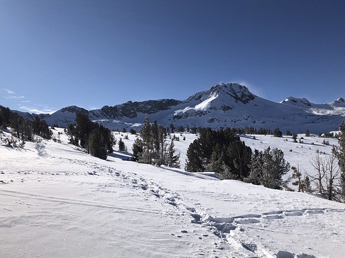
Yes, Kirkwood does rent snowshoes, at their cross country ski shop, and we got some and headed to the Carson Pass Sno-Park, the site of many Sno-Man building activities in our childhood. We strapped on the shoes, neither of us having ever used them before… and off we went. Snow shoes are pretty self explanatory, "just don't try to walk backwards," they said at the shop. Though the amount of snow cover thoroughly suggested WINTER, the sun was out, there sky was crystal clear, and our blood was warmed almost immediately as we stomped the powder on the course of the Pacific Crest Trail, southbound. No specific goal in mind, just an outing in the snow. And it wasn't long before that old buddy, Round Top poked it's head above the trees. While I would have been perfectly content to make the summit of, perhaps, Elephant's Back, (reasonable, yes) Round Top came into focus, and Alex uttered the magic words: "it doesn't really look that far." The unfinished business with Roundtop had been brewing inside him from childhood as well. We were in the same sled, having both been up before, but never to the true summit. As soon as he invoked the spell, there was no turning back. The objective was clear.

The climb begins
There were snow shoe and cross country ski tracks all the way to Winnecmucca Lake, or the place where Winnemucca Lake would have been, had it not been replaced by a crystalline white velvet blanket, and we met one fellow traveller, on his way back from the Roundtop / Sisters saddle. We pressed on. Having no experience with the snow shoes, it didn't seem like the conditions were that great (we were still sinking into the snow fairly deep), and aside from the shoes themselves, we weren't REALLY properly geared up for this expedition, having minimal jackets, and only just raided our parents' coat closet for mittens and hats. Once in the shadow of the mountain, it got cold. And when we gained elevation towards the saddle, the wind picked up, and it got colder, but views were opening up all around of the Sierra landscape. The fine peaks of the Carson Pass area were on display, as well as a plethora of others, in the distance. The route to Round Top was vaguely familiar to us, having been here before, but it seemed almost another life ago. And we'd never been here in the snow, of course.  Reaching the saddle on the west side of the peak, we were back in the sun, and feeling enthusiastic about making the summit. The snow thinned out over the chunky apron of basalt, and we soon jettisoned the snow shoes. Even though Mount Lassen in July had been quite still rather snow covered, this was my first winter ascent of a big mountain, and my gut was filled with an elixir of excitement, tinged with a droplet of dread.

Almost there
The dread comes when you start climbing the steep parts, when you have volcanic rock that's already unstable, even under the best conditions, then you cover it with snow, so you can't even really see what you're working with as far as footholds and handholds. Getting to the first summit was no big deal, but we were now confronted with the notch between us and the true, higher summit, which we handled by cutting down to the south, around the bottom of it, and slowly making our way up the class three climb to the peak. Alex did a fine job picking the route. We took our time, carefully brushing away snow from the rock to find purchase for our cold stiffened claws. There was no thought of recklessness, as It was an almost 3,000 foot drop to the floor of Summit City Canyon at our backs, a constant reminder of where negligent behavior would send us. The care and persistence we took in making a path to the top paid off, and we were soon enough in a place neither of us had been before, the true summit of Round Top.

In the shadow
Having over 2500 feet of prominence, Round Top affords a 360 degree view of the entire area. With a naked eye, we could see past Lake Tahoe to the north, down the Dardanelles in the south, and even Mount Diablo was visible as small gray lump in the west. We didn't bother looking for the summit register in the snow, but spent a few minutes taking pictures in all directions (N-NW-W-SW-S-SE). After this, we had no other objective but to return the snow shoes to Kirkwood by the time they closed at 4PM, and we were gonna be cutting it close. Coming down, it was even colder now in the wind chill and shadow of the mountain, almost brutally so. But we pushed on, not always following our own tracks back, but following somebody's. When we got close to the parking lot, this proved to be a problem, because there were quite a few trails in the snow down there, causing us to follow the wrong ones and fumble around looking for the PCT again. We were rather frosted and fried, back in the pine trees, and everything was starting to look the same. Luckily the shoes were returned just in the nick of time, and we were then free to reflect on the day's accomplishment over heartwarming beverages in the Kirkwood Saloon.

FURTHER READING
•Round Top on Summitpost
•A winter ascent by Bob Burd
•Norcal Hiker 
•Alltrails

Map by National Geographic

Round Top: December 27, 2019