

DISTANCE: 8.17 miles
ELEVATION GAIN: 1566 ft.
TIME TAKEN: 3:45 hours
SUMMIT: Clear Ridge: 1,209 ft.
ANDREW MOLERA STATE PARK
MONTEREY COUNTY, CA
PHOTO ALBUM
MAP
An epic Pisces birthday camping trip at Fernwood Resort in Big Sur was to begin on Friday, so Amber (she was one of the celebratory Pisces, not me) and I jumped in her cozy van, and got a head start. We saw Church Of Misery and Black Wizard play at the Catalyst in Santa Cruz the night before, and crashed in the van, after a late night of revelry. I managed to drag myself into consciousness by 7AM, and continued the journey to the familiar pre Big Sur stop of Carmel Safeway, where additional supplies were acquired for the weekend. I continued behind the wheel to the day's hiking destination, Andrew Molera State Park. Neither of us had been there before, but it had come highly recommended to me, by various books and websites. It had a reputation as one of Big Sur's finest coast hikes, but I didn't think it could be comparable to last year's visit to Garrapata. Could anything?
 | |
| Ridge Trail |
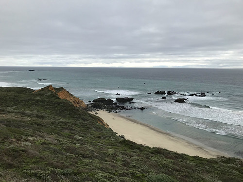
The hike began right away with a crossing of the Big Sur river, which required shoe removal and the experience of some rather cold water. I was glad that we were crossing it today, and not tomorrow or beyond, when rains are supposed to pelt the area. Across the river began the Creamery Meadow Trail, which was basically a very flat dirt road. Almost immediately, we saw a bobcat in the middle of the path, and I was too mystified to try and take a picture, having never seen one before in the wild! Planning to make a loop out of the Ridge and Bluff trails, we had our choice at the intersection, and we chose to do the Ridge Trail first, so up we went. I saw a large and loud group of hikers coming up behind us, so I tried to pick up the pace. It was overcast and rather cool that day, but after some steady uphill, I shed my extra layers and hiked in a t-shirt. Looking back down the trail, we seem to have outrun the large group that was encroaching, but likely, they turned back for some reason. Ah. Sweet solitude. The elevation gain now revealed an excellent view of the coast and Point Sur in the distance. The grassy coastal scrub of the ridge soon gave way to oak forest, then second growth redwood.

At the crest of the ridge, which is where there trail turns south, towards the beach, I went uphill a little bit, along the park border line, and found the Clear Ridge benchmark, the high point, I must assume. It sure looked like it. Just over the park boundary, across a fence, one could glimpse a neighborhood of private homes, temporarily disrupting the illusion of the wild coast. What I would call a fire road for the entire hike so far, now became a steeper, narrower and altogether more fun kind of trail as it plunged down toward the foaming waves of the coast. There were a few other hikers out enjoying the mild afternoon.
We found a nice patch of reddish dirt along the way, to sit, where I devoured my Safeway deli sandwich, and Amber probably ate something much nicer. This was now the Bluff Trail, and it led us back towards our point of origin, parallel to the Ridge Trail, but at a lower elevation, hugging the coastline. The scenery was nothing to complain about! The trail wound us through the coastal undulations, up and down a few ravines, and finally back to the Creamery Meadow trail junction. As Friday afternoon got later, there were were more groups of families on their way into the park. Crossed the river again on the way back, and much much to our delight, we saw the bobcat again (presumably the same one?) in the barnyard of the old Molera estate. We now had the impression that this is probably the "house" bobcat, and he hangs around the area all the time!
Soon after drying our feet and picking out the sharp little rocks, we were in the van, on the highway, and approaching Fernwood Resort, where a hoard of San Jose and Oakland metal heads and other assorted scoundrels would soon assemble for two nights of food, drink and revelry, the like of which does not need to be described on a hiking website!
To be continued...
FURTHER READING
• Hike Speak: Description of the loop
• The Outbound
• California Through My Lens
• 101 Hikes In Northern California: Matt Heid: Wilderness Press, 2000: pp 24-25

No comments:
Post a Comment