DATE: Friday, December 27, 2019
DISTANCE: 7.36 miles
ELEVATION GAIN: 2074 ft.
TIME TAKEN: 6:12
SUMMIT: 10,381 ft. SPS OGUL
MOKELUMNE WILDERNESS
ALPINE COUNTY, CA
PHOTO ALBUM HERE

Round Top. This is a mountain that I go way back with. The first Sierra Peak I ever climbed, my first time over 10,000 feet, my first "real" mountain, with exposure, scrambling and a rocky crown. But I realized not too long ago, during this personal surgence in "summit oriented hiking," that I had never made it to the true summit. Two or three visits had been made during childhood, coming up Highway 88 out of Jackson for Sierra Nevada day hike family excursions. It didn't cross my mind until recently whether or not I had made it to the "actual" top or not, but a conversation with my father confirmed that we had never crossed the gap between the false (western) summit and the true eastern crag. I know I would have returned to Roundtop sooner or later, for nostalgia purposes, but the quest to reach the "top" of Round Top added fuel to the fire and some sense of urgency.
 |
| Looking east at the summit |
Round Top. It's not really that round, is it? Maybe only in the sense that it's not exceptionally pointy. But it turns out it was probably named for The Battle of Little Roundtop, by confederate sympathizer gold miners in the area, as were nearby Little Roundtop and Jeff Davis Peak. Why confederate sympathizers would want to name a mountain after a battle that the confederacy lost is beyond me, but the south had a lot of other backwards ideas too. Yes, Round Top is only rounded in the vaguest sense, like if you squint your eyes and blur it all together into one shape. But if you open your eyes fully, you will see that the top is quite jagged, four district lobes of varying prominence. Lacerated, crumbling basalt, looking somewhat like one of my poorly maintained toenails (eww!). Turns out at one point there was a different name the mountain,
Silver Era Peak, which I find to be much more elegant and distinctive. If the Native American name is not known, let's have Silver Era at least!
 |
| Two Sentinels over Kirkwood |
Visiting our parents in Jackson, lingering temporarily after the Christmas holidays, my brother Alex and I found ourselves alone at the house, with our parents back to work, and younger brother Axell also back to The Bay. A conversation began something like this:
"Let's go up to the mountains tomorrow!"
"Let's go up to Carson Pass and look at the snow!"
"Let's see if Kirkwood rents snow shoes!"
"Maybe we can hike out in it a little bit!"
Friday morning, we were up pretty early, stopping only for snacks and then continuing rapidly uphill towards our destination. I hadn't been up Highway 88 past Pine Grove in years. In general it looked the same, but small things were different. Too many things to remember accurately, or categorize. Soon enough, the snow took hold, and we were in the alpine wonderland of the Sierra Nevada. Like I said, it had been years. Too many years. Everything looked familiar, having seen it before, but it all looked different too, seeing it with adult eyes, these worn down, jaded eyes. It didn't look any less beautiful. The brutal majesty of Carson Spur, cold, black volcanic rock. Not the welcoming granite of Lake Tahoe or Yosemite. It still felt like
the gateway to another world.
 |
| First sight |
Yes, Kirkwood does rent snowshoes, at their cross country ski shop, and
we got some and headed to the Carson Pass Sno-Park, the site of many Sno-Man building activities in our childhood. We
strapped on the shoes, neither of us having ever used them before… and off we went. Snow shoes are pretty self explanatory, "just don't try to walk backwards," they said at the shop. Though the amount of snow cover thoroughly suggested WINTER, the sun was out, there sky was crystal clear, and our blood was warmed almost immediately as we stomped the powder on the course of the Pacific Crest Trail, southbound. No specific goal in mind, just an outing in the snow. And it wasn't long before that old buddy,
Round Top poked it's head above the trees. While I would have been perfectly content to make the summit of, perhaps, Elephant's Back, (reasonable, yes) Round Top came into focus, and Alex uttered the magic words: "it doesn't really look that far." The unfinished business with Roundtop had been brewing inside him from childhood as well. We were in the same sled, having both been up before, but never to the true summit. As soon as he invoked the spell, there was no turning back. The objective was clear.
 |
| The climb begins |
There were snow shoe and cross country ski
tracks all the way to Winnecmucca Lake, or the place where Winnemucca Lake would have been, had it not been replaced by a crystalline white velvet blanket, and we met one fellow traveller, on his way back from the Roundtop / Sisters saddle.
We pressed on. Having no experience with the snow shoes, it didn't seem like the conditions were that great (we were still sinking into the snow fairly deep), and aside from the shoes themselves, we weren't REALLY properly geared up for this expedition, having minimal jackets, and only just raided our parents' coat closet for mittens and hats. Once in the
shadow of the mountain, it got cold. And when we gained elevation towards the saddle, the wind picked up, and it got
colder, but views were opening up all around of the Sierra landscape. The
fine peaks of the Carson Pass area were
on display, as well as a plethora of others, in the
distance. The
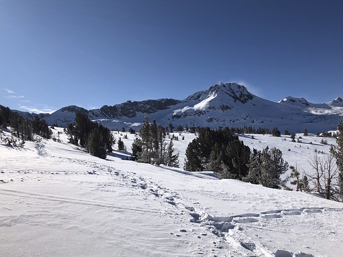
route to Round Top was vaguely familiar to us, having been here before, but it seemed almost another life ago. And we'd never been here in the snow, of course.
Reaching the saddle on the west side of the peak, we were back in the sun, and
feeling enthusiastic about making the summit. The snow thinned out over the
chunky apron of basalt, and we soon jettisoned the snow shoes. Even though Mount Lassen in July had been quite still rather snow covered, this was my first winter ascent of a big mountain, and my gut was filled with an elixir of excitement, tinged with a droplet of dread.
 |
| Almost there |
The dread comes when you
start climbing the steep parts, when you have volcanic rock that's already unstable, even under the best conditions, then you cover it with snow, so you can't even really see what you're working with as far as footholds and handholds. Getting to the first summit was no big deal, but we were now
confronted with the notch between us and the true, higher summit, which we handled by cutting down to the south, around the bottom of it, and slowly making our way up the class three climb to the peak. Alex did a fine job picking the route. We took our time, carefully brushing away snow from the rock to find purchase for our cold stiffened claws. There was no thought of recklessness, as It was an almost 3,000 foot drop to the floor of Summit City Canyon at our backs, a constant reminder of where negligent behavior would send us. The care and persistence we took in making a path to the top paid off, and we were soon enough in
a place neither of us had been before, the
true summit of Round Top.
 |
| In the shadow |
Having over 2500 feet of prominence, Round Top affords a
360 degree view of the entire area. With a naked eye, we could see past Lake Tahoe to the north, down the Dardanelles in the south, and even Mount Diablo was visible as small gray lump in the west. We didn't bother looking for the summit register in the snow, but spent a few minutes taking pictures in all directions
(N-NW-W-SW-S-SE). After this, we had no other objective but to return the snow shoes to Kirkwood by the time they closed at 4PM, and we were gonna be cutting it close. Coming down, it was even colder now in the wind chill and shadow of the mountain, almost brutally so. But
we pushed on, not always following our own tracks back, but following somebody's. When we got close to the parking lot, this proved to be a problem, because there were quite a few trails in the snow down there, causing us to follow the wrong ones and fumble around looking for the PCT again. We were rather frosted and fried, back in the pine trees, and everything was starting to look the same. Luckily the shoes were returned just in the nick of time, and we were then free to reflect on the day's accomplishment over heartwarming beverages in the Kirkwood Saloon.
FURTHER READING
•Round Top on Summitpost
•A winter ascent by Bob Burd
•Norcal Hiker
•Alltrails
 |
| Map by National Geographic |