Showing posts with label County High Points. Show all posts

Saturday, May 1, 2021

Mount Saint Helena

DATE: Saturday, May 1, 2021
DISTANCE: 15km / 9.32 miles
ELEVATION GAIN: 742m / 2433'
TIME TAKEN: 6:10
ROBERT LOUIS STEVENSON STATE PARK
NAPA COUNTY, CA
STOLEN WAPPO LAND
SOUNDTRACK: Archon: Helena

SUMMITS:
• Mount Saint Helena: 1324m / 4343'
• Mount Saint Helena South Peak: 1280m / 4200'
• Hole In The Rock: ?

PHOTO ALBUM
MAP


Mount Saint Helena had been on the hit list for a very long time now, it being the crown peak of the North Bay, and the second highest peak of the Bay Area (not to mention the Napa County high point). It required a visit. It was also high time for a hike with my brother, Alex, and since he was a weekend warrior, we set off that Saturday morning, the first of May, I picked him up from his apartment in San Francisco's Western Addition, and we were off, cruising the highways major and minor, arriving at the Stevenson Memorial Trailhead at 9:25AM, We didn't waste any time getting onto the well constructed trail, which had been engineered with well crafted steps and switchbacks, rising through a forested belt of oaken woodland that had been spared from the recent fires. Within 25 minutes, we were getting up out of the trees, and now had views to the east of the table rocks, and Calistoga Valley from the south to the north. In less than a mile, the single track trail ended, and the journey continued on a dusty fire road. At the western point of sharp switchback, we came to a big rock, and decided to do some gratuitous scrambling. This was fun, but also very lucky, because it gave us a view of a feature called Hole In The Rock, which we probably wouldn't have seen otherwise. The landscape in this area had been burned over, and there were faint climber's trails through the brush, so we decided to visit the enticing rock feature in the distance. We plied the rocky tracks and added more class 3 along the way, maybe unnecessary, but there was a fixed rope at one point, which means we weren't the first to go that way by any means. By about 10:30AM, we were at Hole In The Rock, which certainly lived up to it's name. We climbed around, through, and even managed to get on top of the thing. We also climbed, or tried climbing some of the adjacent big rocks. Exhausting the possibilities of the area, for the most part, and feeling the need to move on, we decided to shortcut uphill to rejoin the road, rather than backtrack, and although there was a trail at first, we either lost it, or it just dissolved, and we were dumped into the day's only bushwhack, which wasn't actually too bad, because like I said, the area had burned last summer, or maybe the summer before.

We rejoined the trail / road at about 11:30AM, Hole In The Rock ended up being the coolest part of the day, and was now behind us. The road took us into the upper reaches of some unburned pines, which offered welcome shade in the warm, sunny day. We diligently followed the road now, and saw many other hikers out on the fine Saturday afternoon. One of them complimented us on our facial hair! As if we coordinated it or something? We reached the top of Mount Saint Helena at 12:15PM, and tried to enjoy the surroundings and the views. There were some people doing an annoying thing, sitting, hanging out RIGHT on the actual highpoint of the mountain. I wandered around for a few minutes, pretending not care, and right before I said to them "excuse, I'm going to have to touch the high point of this mountain," they finally moved. Not as bad a move as people sitting down in the middle of the trail, but come on! Confrontation avoided. This time. Now that we had reached the main summit, I informed Alex that Mount Saint Helena had three sub-peaks, and he said

"I'm not going to all of them," and I said

"OK, let's just go to the East Peak?" 

partly because that one is also on the California Coastal Peaks list, but more importantly, I wanted to get a good photograph of the main peak. East Peak was a class one walk up on gravelly rock, to more communications towers. We didn't hit any other peaks after that, but we did take a little jaunt north to a rocky, piney point. This proved very worthwhile, as it actually gave the perfect photograph angle of the main peak that I'd been wanting. By now, it was almost 1pm, and time to head down, so it was back upon the dusty road, amongst hikers of all stripes, many in large groups, perhaps school chums they were. There wasn't much to stand in our way on descent, and we were back at the van at 2:30PM. But the "bros day out" wasn't over yet. We went into Santa Rosa to get some Vietnamese food, then hit one of my all time favorite breweries, Moonlight, and then another brewery! Henhouse! Oh boy. It was hot outside, and the biergarten was crowded, and we were then a little tipsy as we pulled down 101, back into San Francisco, and finally to Owl band practice with our third, youngest brother. 

FURTHER READING
• Mount Saint Helena on SUMMITPOST and PEAKBAGGER
• Mount Saint Helena East Peak on PEAKBAGGER
MODERN HIKER


Friday, March 20, 2020

Copernicus Peak

DATE: March 20, 2020
JAMES LICK OBSERVATORY AREA
SANTA CLARA COUNTY, CA


SUMMITS
•Copernicus Peak: 1329m / 4360 ft. 

•Tycho Brahe Peak: 1280m / 4200 ft. 

PHOTO ALBUM


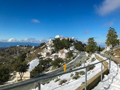
I was down in San Jose, just before the Coronavirus got really serious. Social distancing was already in affect, but not shelter in place. Or at least I wasn't sheltering in place yet. There had been some pretty heavy weather lately, so Amber offered to give me a ride up to Mount Hamilton to see the snow that had accumulated there. I had never been up to Mount Hamilton in the snow before. I had never been to Mount Hamilton at all! She knew I wanted to visit the place very badly. So we took the long and winding road all the way up, a drive that would have been cumbersome in my giant passenger van, but was a breeze in her nimble Subaru. Past 4,000 feet there was still some snow left on the ground from a storm that had brought only rain to the lowlands. We parked the car and just walked around the area. Due to Covid-19 (or other reasons?) The James Lick Observatory, which normally has visitor hours, was closed. As was the parking lot of Mount Hamilton proper. So I didn't even visit the feature that the whole area is named for. But I had loftier goals in mind. Apparently, the massif which is generally called Mount Hamilton is actually divided into eight sub-peaks, including Mount Hamilton proper (AKA Observatory Peak), and the seven others, all named after astronomers throughout history. The actual highest point of them all is Copernicus Peak, the highest point in the Santa Clara County and the highest point in the nine county Bay Area region. As a "summit oriented" hiker, you can understand why I wanted to visit it so badly. Here are the eight sub-peaks in order from highest to lowest:

1. Copernicus Peak: 4360+
2. Hipparchus Peak: 4240+
3. Kepler Peak: 4240+
4. Mount Hamilton / Observatory Peak: 4213
5. Tycho Brahe
6. Gailleo Peak: 4177
7. Huyghens Peak: 4160+
8. Ptolemy Peak: 4040+


HERE is a map that lays them all out

A citadel of science

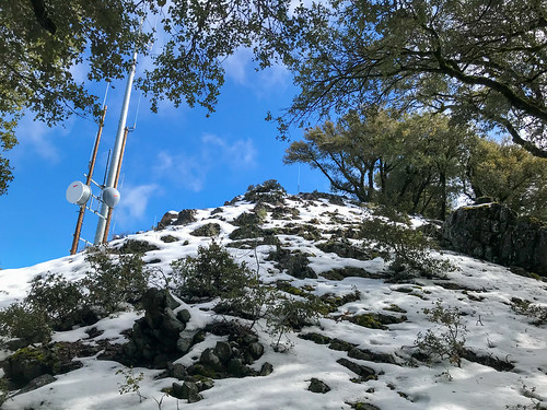
We walked around the summit area, down the roads and stuff, looking at the telescopes, the astronomer's facilities, taking pictures. There was a ghostly vibe because the astronomers sleep during the day, and work at night when the stars are out. Aside from two other casual visitors, we did not see anyone around. I later surmised that during our wanderings, I unintentionally crossed over Tyco Brahe Peak along the way. Although I was aware at the time that the eight different sub-peaks existed, I wasn't trying to tag them all: maybe if I come back alone some time. Visiting all the sub peaks seemed like a tedious task at the time, and I wasn't trying to test Amber's patience, though I'm sure she would have understood. She DID understand why I had to walk up a gated, "no trespassing" road, through the snow, to reach the top of Copernicus Peak. She waited at the bottom. The top was crowned with an old lookout tower and some radio equipment. I took a few pictures and came back down the same way I came up. 

Looking up Coppernicus peak

It was a crisp, clear day, and there were good views all around, Mount Isabel to the south, Santa Cruz Mountains to the southwest, and the mysterious private property peaks of the Diablo Range to the north. All in all, I was stoked to finally reach the highest point in the Bay Area, and see the Mount Hamilton area , a self contained astronomer's village within sight of San Jose, but a world apart. In the snow, it felt even more removed from the reality of the valley below, akin to visiting an arctic research station.

Much later in the day, an outing was made to the Calero Creek Trail in San Jose, a few photos of which can be seen here.

FURTHER READING
Bob Burd: Bob tags all the sub peaks of Mount Hamilton
Summitpost: Information On Copernicus Peak
Will Hite Web: Info and pictures of Copernicus Peak
Hiking Project: Information on the Calero Creek Trail

Wednesday, January 1, 2020

Mount Diablo 2020

DATE: Wednesday, January 1, 2020
DISTANCE: 11.7 miles
ELEVATION GAIN: 4168 ft.
TIME TAKEN: 7:40 hours
MOUNT DIABLO STATE PARK
CONTRA COSTA COUNTY, CA


SUMMITS
MOUNT OLYMPIA 2946 ft.

MOUNT DIABLO NORTH PEAK 3557 ft.
MOUNT DIABLO SOUTH PEAK (x2) 3849 ft.
DEVIL'S PULPIT 3640 ft.
RANSOM POINT 3485 ft. 

MOUNT DIABLO PREVIOUSLY CLIMBED ON 2/5/19 

PHOTO ALBUM

"THE SEVEN GATES OF DIABLO" #1


Since the year 2020 is intended to be the most hike filled one yet, why not start it off on the right foot… by going on a hike! Mount Diablo was on the agenda for today. (To read about my deep feelings on this particular peak, check out last year's report) I picked my brother Alex up up about 9:30am. Probably the earliest I've gotten up on New Years Day since well… ever? Usually, I'm STILL UP at 9:30am from the night before! We cruised through no traffic to the magic tunnel gateway of the eastern wastes, Contra Costa County, and hit the Safeway out by Clayton Road for snacks and supplies. My plan was to approach the mountain from a different angle than last year, and hit two new summits. To facilitate this, I parked us in an unmarked, free turnout on Marsh Creek Road, where it meets the gated, dirt grade Sharkey Road. This trailhead is not highly publicized, but luckily it is featured on the nice Mount Diablo Interpretive Foundation Map that I had purchased at the gift shop last time. There were three or four other cars in the turnout when we arrived at about 10:40 AM. And we were off. Sharkey road curved gently through the luxurious tall grass and rolling oak studded foothills. 2020 was going well already.

Sharkey Road
Bouncing between dirt roads and trail, we began to gain some elevation. Sharkey Road to Olympia Trail, Wise Road, back on Olympia, and the to the East Trail, which began lurching back and forth up the steep hillside. Everything on Diablo is well signed. Cool rock formations cropped out above us, and Mount Olympia, the first destination, loomed overhead. Views opened up from Northwest to Northeast. We left the trail for a bit to scramble over onto some nice rock formations and take a short break. Up to Mount Olympia, which is really just one of a series of bumps on a north-south oriented ridge that juts out from North Peak. But this is the only one that has a name. We found the summit sign post toppled over, and there were two completely full notebook summit registers in a receptacle on the post, which we didn't bother to dig through, to look for a place to squeeze our names in.

North Peak
Onward and upward, as they say! From Mount Olympia, North Peak Trail contours along the west side of the ridge, eventually meeting North Peak Road, a 4WD route for the purpose of servicing the radio transmitters at the top. At this intersection, there is a small cinder block structure, and some leering face! Up the loose gravel of North Peak Road, and to the top, where a few people and many, MANY communications apparatus commanded the view. It would be the best we would have that day, as the higher South Summit was shrouded by fog by the time we got there. At this point, we had a good site of Mount Diablo proper, (south peak) looming in front of us, and in typical Alex fashion, he said "It doesn't look that far away." My only intention had been to scale Mount Olympia and the North Summit, the two I hadn't been to before, but Alex had only ever driven to the top of Diablo, and who was I to deny him this chance to hike it? So I threw away the rest of my day, and we carried on down the road to Prospector's Gap, and up the next summit continuing on North Peak Trail. Traffic had been moderately thick on the trails so far, and now there were a whole shitload of people coming to North Peak as we went down, trying not to slip on the gravel and embarrass ourselves in front of the moms and dads and kids and grandparents and dogs. Lunch break on a rock outcropping near Devil's Elbow. I ate half of my Safeway turkey sandwich. Vegan January is going to start TOMORROW!

Mount Diablo Observation Tower
It was around lunchy break time that a big cloud bank came in and engulfed the top of Mount Diablo above us. Our path was set, and we went up anyway of course. At the observation deck, we had a nice view of the inside of a cloud, and that was about it. Lots of people milling about, as they all had the holiday off work. We got away from most of them by heading east to Devil's Pulpit, an ominously named, (and today, quite ominous looking) rock outcropping nearby, which I had failed to visit last time. Some barely class 3 will get you to the top. Now it was into the unknown! I wanted to hit one more named sub-peak, Ransome Point, so we circled around to the north side and walked down what at first seemed to be an obvious use trail. It quickly degraded into something more like a tunnel through thick underbrush that we had to duckwalk and almost crawl through at some points, but it got us to Ransome Point, a thorn of stone that juts from Mount Diablo's north shoulder. At this point, we should have followed the crappy trail back to the mountaintop, and continued our journey on the real trails, but instead we decided to try our luck going cross country towards Prospector's Gap. I had seen some unmarked semi trails shooting up from that area on the ascent, and I figured one of them was probably a conduit Ransome Point and the Gap, and we would run into it really soon. No such luck! It was a nasty bushwhack section as we tried to contour along the hillside. There was plenty of loose gravel to slip on, and brush so thick that I was slithering on my belly to get past some of it. Eventually, after much stupid thrashing and stumbling, we did reach an unofficial track that soon joined the North Peak Trail and dumped us back at Prospector's Gap.

Alex at the falls
Standing at the crossroads, we had to choose our return route. We decided to take a longer and more arduous path to see how the waterfalls were doing. More new territory for the Alex man! Down Prospector's Gap Road, to Middle Trail, and then onto the waterfall loop. The falls were not going off as much as last time. I still want to climb up Wild Oat Canyon someday, and see the rest of the waterfalls, but the flow didn't merit that kind of exertion, plus it was getting late of day at that point. Cardinet Oaks road to Olympia Trail, which at this point, in order to avoid a chunk of private property, switchbacks steeply uphill for a good while, and I was getting pissed off. I didn't want to go uphill anymore! We should be going down now! Shut up, crybaby in my mind! SHUTUP!!! Headlamps went on at 5:35PM. Past the junction with the East Trail, we were just retracing old territory. Slogging back to the van. We made it. It was a much longer day than I had expected we were going to do! Alex demanded Scotch Ale, because he had gotten a vision of Scotland from the grassy hills and crisp winter air. So we went and got some back in Oakland! Beer free January is going to start TOMORROW!

Map from Mount Diablo Interpretive Association


Mount Diablo 1/1/2020

Saturday, May 11, 2019

Mount Tamalpais East Peak

Looking up towards the East summit
DATE: Saturday, May 11, 2019
DISTANCE: 10.6 miles
ELEVATION GAIN: 2400 fee
TIME: 5.5 hours
SUMMIT: 2572 ft.  
MOUNT TAMALPAIS STATE PARK
MARIN COUNTY, CA 
SOUNDTRACK: Deathrow: Hell's Ascent

PHOTO GALLERY


To get a sense of it's scale, I wanted to approach Mount Tamalpais from a point near the bottom, and go up what looked to be the steepest part, the Eastern ridge. There are plenty of trailheads farther up, with easy driving access, and shit, you can drive all most all the way up to the top if you want(!), but I'm not here to do things the easy way. I picked the Piedmont Trailhead, near Larkspur as my jumping off point, and parked the van in a dainty residential neighborhood. Fumbling around at 6:40 AM in the foggy semi darkness, I veered off the Piedmont trail, because I didn't want to go into what looked like someone's driveway, and took an unintentional turn up into the Blithedale Ridge Open Space, a unplanned, non linear detour down Southern Marin Fire Line Road and Huckleberry Trail.

Flowers along the trail
Soon enough, I was heading due Northwest again on various fire roads, until I veered onto a trail off of Indian Fire Road. This pretty much went straight up the steepest part of the Eastern Ridge on what was at times a partly overgrown trail, and at others, a steep rocky drainage ditch. It was a relentless, knee killing climb, at it was somewhere along here that I got above the layer of clouds, and was looking down at a sea of silvery white, with only Mount Diablo poking through in the Eastern distance. Finally got to the paved loop around the top, and heard the voices of fellow hikers, of which there had been very few up until that point. (A few doggers and jog walkers in the lower regions)


The welcoming watchtower
I quickly went to the top, past the gravity train barn and right up to the sealed shut, locked up Mount Tam Lookout tower. Clouds blanketed the the Earth as far as I could see, with only a few peaks in Marin, the North Bay, and the aforementioned Diablo poking above. To the West, the Tam ridge descended into coastal fog. I quickly dropped down the verdant Fern Canyon trail, which had some nice little waterfalls, around the South side of the mountain on Old Railroad Grade road, and on to Hoo-Koo-E-Koo road, back to the crossroads on the East side where I had been before. Not wanting return the way I had come, back over the unnecessary climb of Blithedale and Corte Madera Ridge, I veered down into Baltimore Canyon on Hoo-Koo-E-Koo trail. A heavily forested switchback path led me to Dawn Falls, which was already down to a mere trickle. I mean I've never seen it before, but based on the rock shelf it pours over, I assume it must be much bigger sometimes. Dawn falls trail heading East along Larkspur Creek, to eventually conjoin with the Piedmont Trail.


Going down Fern Canyon
Past Dawn falls is where the crowds of norm dog hiker families started to get thick, and I was forced to remember that it was a Saturday in a very populated area. "Do you know what poison oak looks like?" "No, i think Grandpa does." "Do you know what it looks like, Grandpa?" Grandpa just smiles and nods. (Grandpa, internal dialog "please kill me now.") A the end of the journey, going out the way I had intended to come in, I was finally able to see where I'd gone wrong at the start, because the Piedmont Trail goes right past some houses, and there are a couple of cars parked on it, that make it LOOK like someone's driveway.

The ass kicking journey

Tuesday, February 5, 2019

Mount Diablo 2019

DATE: Tuesday, February 5, 2019
DISTANCE: 11.9 miles
ELEVATION GAIN: 3500 ft.(+-)
TIME TAKEN: 7 HOURS
MOUNT DIABLO STATE PARK
CONTRA COSTA COUNTY, CA 
SOUNDTRACK: ZZ Top: El Diablo

SUMMITS
MOUNT DIABLO NORTH PEAK: 3849 ft.
BALD KNOB: 2645 ft.
EAGLE PEAK: 2369 ft.
TWIN PEAKS: 1733 ft. 
MITCHELL ROCK:  1080 ft.

MOUNT DIABLO CLIMBED AGAIN 1/1/2020


I hadn't been to the top of Mount Diablo since the 80s, when I was a wee lad, and my parents had driven us to the top. I do not remember this. I take their word for it, and ever since moving to California in 1990, the specter of the shadowy mountain has lurked at the edge of my consciousness, the edge of my imagination. It was visible right out the front door, 70 miles away, from where I grew up in Jackson, CA. The fiery California sun would set the horizon ablaze most evenings, Diablo a silent, waiting tombstone for the Helios grave. When I moved to Oakland in 2000, the El Diably was much closer, but much less visible, barely thought of. Only on stoner trips to the highest ridges, and journeys out of town, past the forbidden zone beyond the Caldecott Tunnel, did it rear it massive head. Centrally prominent in the middle of the East Bay population center, yet mysterious to most. A thieves thicket of winding paths, dead end canyons, dark peaks and tortured rock formations. Why did I wait so long to return to Mount Diablo? Well, why did I wait so long to do A LOT of things? Answer me that. I won't like the answer. A whimsical drinking picnic to Rock City in late 2017 was not even an appetizer, it was a midday snack. But it was sometime in 2018 when I made it my goal to hike every major peak in the Bay Area from base to summit, the hardest way possible. I wanted to FEEL the size of each mountain. And Mount Diablo is one of the major-ist of the major peaks around, so it had to be done.  

Then the right time came. Tuesday, February 5, 2019.  I had the whole day off of work and it was one of those magical rare times when Mount Diablo gets a powdering of snow, so I set out from home as early as I could manage to make my pilgrimage the (temporarily) silver mountain! Popping out of Caldecott Tunnel and pushing East, I could see that the upper slopes of Diablo were graced with snow! But the summit it's self was shrouded in clouds. I hoped they would blow away before I reached the top! But there were many hours for that to happen. Cruised out through the suburban environs of Walnut Creek and up Ygnacio Valley road. Hit a CVS or something for water and snacks. 

With the added enticement of heavenly dandruff upon the shoulders of the giant, I began my journey from the Mitchell Canyon parking lot. To me this seemed like a suitable jumping off point that I could call "the bottom" of the mountain. Wanting to make up for my years overdue absence from the sleeping behemoth in the Bay Area's backyard, I planned an ASS KICKING agenda for the day, one that would take me all the way to the summit, as well as to several sub peaks and minor attractions. The muddy roads and dog walk domain of the lower regions gave way quickly as I hit the Mitchell Rock trail and began climbing. Sweet ascent. It wan't too long before I had sweeping views to the North, of the canyon I had come up out of, and the ziggurat hillside of the nearby quarry. I could now see clearly how much snow had fallen on the upper heights, and it wasn't too long before I came across my first light patch of the white fluffy stuff, so rare to see in the Bay Area! Mitchell rock was an elementary scramble up to a raptor's perch, with a straight shot looking North down the valley. To the south, I caught a view of the various heights that awaited.


The trail continued upward steadily from there, through manzanita and scrub oak. I could imagine how hot and baked this terrain was in the summer, but now it it was mystically frosted with new snow. Views to the North expanded, and I could now see into the Sacramento River Delta. Up, with more brush snowy brush tangles.  The next summit to attain was Eagle Peak. This is one of the many Eagle Peaks in California, but today, THIS ONE was mine, and mine alone. No other humans had been sighted since I left Oak Road. Atop Eagle Peak, there was a crumbling vulcan turret and few other signs of life. Ominous snowy peaks towered around and above me. Dustings of snow and light manzanita were the main landscape. I became temporally lost at the five point intersection at Murchio Gap, and I accidentally walked South on Meridian Ridge Road for awhile, before realizing that "this must be wrong," and going to back to find the Bald Ridge trailhead, which was a little bit obscured at the entrance. And it was a far cry from the muddy jeep of track of Meridian, no doubt. Bald Ridge Trail was, for the most part, a snowy underbrush tunnel, and I stripped down to a t-shirt, in spite of the weather, as I barged ahead through what felt like serious elevation gain. Panting and sweating, I burst from the underbrush at the next junction, Prospector's Gap, a mud puddle crossroad in the pass between the North and South summits of El Diablo.

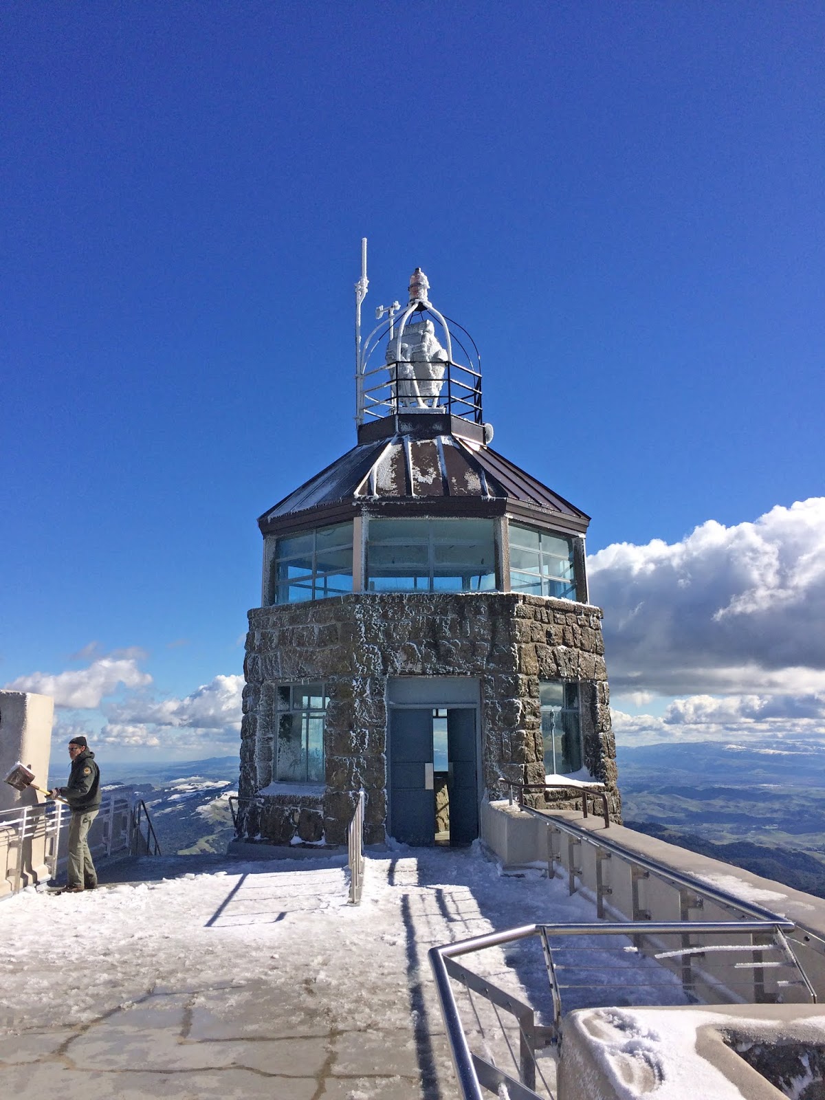
Here, I turned South on the North Peak trail (huh?), which would wind me around to the South (main) peak of Mount Diablo. There was an excellent view of the North Peak, a snowy clattering brook pouring down the hillside, and an ominous dark boulder which had genuine motherfucking ICICLES on it! The thrill of seeing snow and ice in this part of California was almost beyond description. Also, to my bewilderment, I saw some strange tracks in the snow. Mountain Bike! What the fuck. Fucking maniacs. I curved around the bottom of the main summit and got a view to the South, where most of the high points for miles had been crowned with snow, as far as I could see. The main destination was in sight at this point. So, while no humans (besides the phantom mountain biker) had been present on my insane miles of uphill rambling, it was not to last. Finally, I reached the summit area, the civilized part of Mount Diablo, the part that you can drive up to, even with Grandma, and your two year old larvae. I heard the screams of adolescents flinging bits of frozen debris, the stern chiding of their guardians; I had returned to society. Paved roads. Buildings. Up to the watchtower I went. The observation deck. I could now look down upon the North Peak, and out across the Bay Area through the Golden Gate. The view from the top is probably one of the best in California, and I took time to soak it in.  There was a ranger bitterly shoveling snow and de-icing the stairs. Inside the gift shop museum in the basement of the tower was a very fine relief map of the whole area, some exhibits about the old Mountain. It was nice to be indoors and warm, temporarily. I sat and ate a banana and some trail mix. Up on the deck next to the tower, I got out my binoculars and looked around. Ideally, I was hoping to see Jackson Butte in the East, my ancestral (well, since 1990) home, which has such a clear view of Diab. But the Sierras and their subsidiary hench-hills were ensorceled with heavy clouds, no doubt the storm that had marauded the Bay Area last night was now casting literal feet of snow upon the grand Sierras. All was not lost. I COULD clearly see as far North as the Sutter Buttes, and spy upon downtown Sacramento and Stockton with my super goggles. To the South, Mission Peak was easily identified, and Mount Umunhum crowned the Southern horizon. I had finally made my heroic return.

Now for the fun part. I had spent too long at the top. I had chosen a steep and circuitous route to get there. I was tired. As I dragged my ass back down the North Peak trail to Prospector's Gap, I decided to forgo my original master plan of also conquering the North Summit. That would wait for another day. As would the waterfalls. I decided to take the most direct path back to my point of origin. Even without the additional summit second entree, and waterfall side dish, I still had a five and a half mile downhill hike to complete my grand loop dinner, pay for the meal, and hopefully have enough left over for a tip. Stumbling on the steep ramp of Prospector's Gap Road, a fire trail for rugged vehicles. It's hard on the feet walking down a road like that. Middle Trail cut through the bush again to re-emerge at a different part of Meridian Ridge Road, my old nemesis. Nothing but wide and bloody muddy fire roads at this point, I pressed on North through Donner Canyon, the road which mostly parallels a sloshing friendly creek of the same name, and some old time settlement ruins that I didn't have the energy to inspect. Cut West across Murchio Road towards where the van was parked, there's and old water tower out there, and the landscape is back to the rolling, oak studded savanna that probably defines the majority of Northern California. Back in the Mitchell Canyon parking lot, I sighed, scraped some mud from my boots, and fired up the 5.9 litre V8 of my 2000 Dodge Ram Van 3500. It is incredibly wasteful of gas to drive this beast solo out to trail heads. It's meant for hauling the entire band and gear. Oh well. Back to Oakland. Park the damn thing. BART to San Francisco. Hazzard's Cure practice. Late night super veggie burrito from Taqueria San Jose. Just remember: you don't have tot eat the whole thing… burritos are easy to save half for later… you don't have to eat the whole thing… burritos are…


CLICK "READ MORE" TO SEE ADDITIONAL PHOTOGRAPHY