DISTANCE: 14.21km / 8.83 miles
ELEVATION GAIN: 712m / 2336ft.
TIME: 5:46
SUMMIT: 3424m / 11,233ft. SPS
STANISLAUS NATIONAL FOREST
CARSON ICEBURG WILDERNESS
ALPINE COUNTY, CA
SOUNDTRACK: Judas Priest: Dissident Agressor
PHOTO ALBUM
MAP
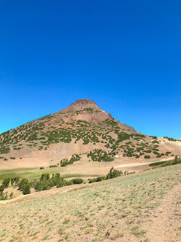
Stanislaus Peak is really a classic butte, steep sided and flat on top, near perfectly shaped, (especially when viewed from the north). To add to it's attractiveness, it has a distinctive reddish color, different from the surrounding peaks, and it wouldn't even look out of place in Utah or New Mexico. It is an extinct volcanic cone, and the farthest north (named) 11'er in the Sierra Nevada. Faced with the choice of climbing either Sonora Peak or Stanislaus that day, with probably not enough time to do both, Axell and I settled on Stanislaus, because it "looked cooler," even though the original plan had been Sonora. The view of Stanislaus' majestic red cone in the distance, on yesterday's hike, had probably sealed the deal.
I awoke in my tent at Chipmunk Flat at 7:45AM, later than I planned. I'd had a helluva time getting to sleep in the tent, even though I was beat from climbing Leavitt. It was already plenty bright out, and with the tasks of eating breakfast, going to shit in the woods, getting water from the creek to dump on the campfire, and striking the tent, we didn't leave camp until about 9:20! This is when I especially realized that we wouldn't have time for both Stanislaus and Sonora, as we would have to leave back to The Bay by 3PM so I could make it to band practice.
Not too far east up Highway 108 from Chipmunk Flat was Saint Mary's Pass trailhead. When I got there, I saw that there were primitive campsites, and I cursed "Damn! We could have just stayed here last night!" From the trailhead, there were views of Margaret Lewis Peak, Mount Finiski, and the The Nightcap. We were on trail dirt at 9:48AM. The only human being we had seen yesterday had been a black dot in the distance, on top of Leavitt Peak. Today, we would not be so lonely, with a troop of backpackers storming out down the trail at us almost immediately. But that was it. Aside from Stanislaus Peak it's self, the most elevation of the trail occurred at the very beginning, going uphill to gain Saint Mary's Pass. There were fascinating volcanic rock formations along the way, including "The Eye." We were on top of the pass in 36 minutes. From this vantage point, there was a good look back at Starvation Ridge, and for the first time that day, an open view north of Stanislaus Peak.
The trail continued down from the pass and became a grandma grade footpath that gently followed along the west side of the ridge, through beautiful meadows and past trickling springs. We made good time on this part, and arrived at the granite outcrop "Stanislaus Crag," in just over an hour. (11:30AM now) Having arrived at the base of the red butte, the trail petered out, and we had to choose our ascent. While on our way up from the crag, we looked through a notch in the rock, which which was a window down into a surprise granite canyon, at least 1,000 feet deep, which had been completely hidden from view on our approach. "Stanislaus Crag," the granite formation, marks the end of the volcanic section of rock, and the beginning of the granite-bound canyon area, which leads down to the East Fork Carson River.
The route up to Stanislaus was an attempt to not lose elevation, so we tried to go due west, but some stubborn, giant chunks of rock would not permit this, and there was indeed some elevation loss and regain. As we started to go up, the only other consideration was to go around the stands of small pine trees, and by that method, our path came to be. Ghosts of use trails came and went, but it was mainly "choose your own adventure" over or around the worst sections of talus and shattered volcanic rock on the steep slope. Reports considered this peak to be a class 2 climb, so maybe there is an easier way to go that we simply didn't find, because our path to the top was decidedly class 3. More fun that way! We took turns going up to the top. I went up first, while Axell stayed below the class 3 section with the dog. The route of ascent was a short, but memorable climb through a jagged landscape, and I guess what you would call a brief chute. Up over the rim, and I was on the flat top, like a pile of broken terra cotta tiles. I found the summit register, and expected 360 degree views, not staying too long, time was on my mind. Then I went down, stayed with the dog while Axell went up to claim his first 11er.
We retraced our steps back down the mountain, as best we could, got back to the granite just before 2PM, and I posed for a "scary" photograph at the edge of the cliff. Now it was time for the long haul back on the wilderness highway of Saint Mary's Pass Trail, past the remaining snowy patches and bright green spring fed bogs. We were back to the van by 3:35PM. Behind schedule, but not disastrously so. Time to travel down, down, through surprisingly heavy traffic on Highway 108, through the foothill towns, through the scorching hot cowshit valley, and eventually back into the foggy embrace of the Bay Area.
FURTHER READING
•Stanislaus Peak on SUMMITPOST and PEAKBAGGER
•Bob Burd: Bob tackles Stanislaus and Sonora in one go
•West Coast Hikes With Dogs: With snow! And dogs!


No comments:
Post a Comment