DISTANCE: 4.25km / 2.64 miles
ELEVATION GAIN: 271m / 890 ft.
TIME: 1 hour
SUMMIT: 1523m / 4,999 ft.
ELDORADO NATIONAL FOREST
ELDORADO COUNTY, CA
SOUNDTRACK: Autopsy: Mutant Village
PHOTO ALBUM
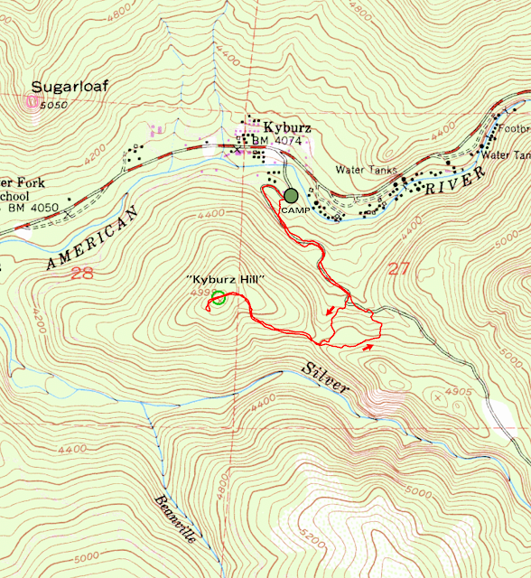
MAP
"Kyburz Hill" is a forested bump, just south of the village of Kyburz, just shy of 5,000 feet tall. It's main significance was that I happened to be near it, and I found an easy way to go up it. NOTE: The main photograph is not KH, I couldn't get a good picture of it, because I was on it. The photograph was taken from KH, looking east in the direction of Eagle Rock.
There was no doubt that this 4th of July would not be normal, as 2020 was by no means a normal year. As much as I love fireworks, I decided to retreat to a private campsite in Kyburz, to be away from as many people as possible. There would be no fireworks in the bone dry forest, but a campout on one of Amber's friend's parents' land that they bought thirty years ago and have only visited once. After getting established in the totally undeveloped camp, digging out the driveway from years of dirt, clearing brush and wood away to form campsites, my stomach was growling... for a hike! While some were content to relax on the private "beach" on the Silver Fork American River, I was keen to explore the area, see if I could get up and out for a view perhaps. I picked the closest thing, and went for it.
Peak 4,999. Up Silver Fork Road and some rustic fire roads got me there well before sunset. Brushy on top, a few views, mainly at Thunder Mountain, the high point of Amador County, to the south. Due to the tree cover and my low elevation, I was not able to get a view of Sugarloaf or Eagle Rock as I had hoped. But I soaked in what I could, and then came back down to the camp after the very short hike, a minor warmup for what was to come the next day.
To be continued...
ON PEAK NAMES
"Kyburz Hill." I nicknamed it such because it is right by the town of Kyburz. When picking my own nicknames for mountains, I try not to rock the boat too much.
FURTHER READING


No comments:
Post a Comment