DISTANCE: ~2.1 miles
ELEVATION GAIN: ~400 ft.
SUMMIT: Fremont Peak 3,173 ft.
FREMONT PEAK STATE PARK
MONTEREY COUNTY, CA
SAN BENITO COUNTY, CA
CLIMBED AGAIN: January, 25, 2019
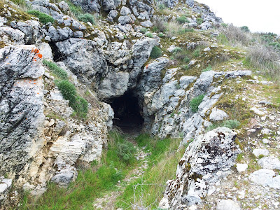
After participating as a chaperone on a field trip to the Mission in San Juan Bautista, Amber reported back that there was an antique store there with a lot of records. I eagerly agreed to participate in a return trip, partly because I love records, and also because it would be a fine chance to check out Fremont Peak, which lies just West of the town. After picking through the dusty vinyl archives and having a cocktail at a local biker bar, we took the long and winding road that goes almost to the top of Fremont Peak. We made a short loop out of it, coming up the road on the East side, and coming back down the trail from the West, with a detour over a fence into some adjacent (presumably) private property which has some caves, and one tunnel that goes straight through Rocky Ridge. I couldn't tell if this was a natural phenomenon, or if the tunnel was bored through the hill for some reason (mining?).
The promise of Fremont Peak was a sweeping 180 degree view of the Monterey Bay area, and although it was cloudy, the clouds were high, and the view was delivered. From the Santa Lucia range in the South, to Loma Prieta in the Santa Cruz Mountains to the North, and everything in between. An easy hike for an incredible payoff.


No comments:
Post a Comment