

DISTANCE: 2.2 mi / 3.54 km
ELEVATION GAIN: 233 ft / 71m
TIME TAKEN: 1 hour
SOLANO COUNTY, CA
NAPA COUNTY, CA
SOUNDTRACK: Melvins: American Cow
SUMMITS
•Mount Vaca: 2819 ft / 859m
•Mount Vaca North Peak 2765 ft / 843 m
PHOTO ALBUM
MAP
Mount Vaca, at 2,819 feet, straddles the border of Napa and Solano Counties, and is the highest point of the Vaca Mountains, a north / south flowing ridge on the eastern edge of the coast range. Most importantly, Mount Vaca is the highest point in Solano County, which is probably what brought me to it today.
I had to go to Fairfield Pick ’n’ Pull to hunt down a part for my van, and since I was in no hurry, I decided to go for a hike in the area, provided I could find something suitable. There are several interesting peaks in the area, but almost all are on private property, with limited access. Mount Vaca is also on private property, but apparently, this is not taken too seriously. So after the junkyard, I drove a little north toward Vacaville on Interstate 80, exited at Cherry Glen Road, continued north on Plesant Valley Road, and then took a left on Mix Canyon Road, which I took all the way to the top of the ridge. 4.7 miles up Mix Canyon Road, there is a a turnoff to the left, which is marked “private property, no trespassing, violators will be prosecuted, etc.”
My paranoia of getting locked inside the gate had me parked outside on the main road, and I walked inside. It was about .3 miles to Mount Vaca’s North Summit, a flatened patch of earth crowned with a radio antenna. I was startled at first, and then amused, as a voice came over a loudspeaker:
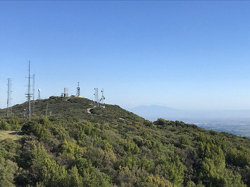
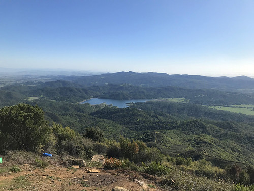
“You are TRESPASSING! Please leave the area immediately! Your image is being recorded on video!” It was a robot voice, probably triggered by a motion sensitive camera. After this magnificent summit achievement, I pressed on for my crowning goal of the day. On down the road, as I approached the main crest of El Vaca, I heard the rumbling of, and soon saw the sight of, a big white truck coming up the road. “Oh great,” I thought, “this is the part where I get yelled at.” But it was a guy from The Governor’s Office Of Emergency Services, and he just asked me if that was my truck up ahead blocking the road. (There was another big white truck up ahead, blocking the road.) Proclaiming my innocence, I continued on my way. The top of Mount Vaca is flattened, and topped with three communications facilities, one of which looks unfinished and abandoned. The area is littered with various debris, suggestive of some kind of tweaker situation, or perhaps a weed grow facility long abandoned. If you can look past the shabby surroundings though, there are good views of the surrounding area, Mount Diablo to the south, Lake Curry and the Twin Sisters to the West, Mount Saint Helena and Cobbs Mountain off to the north, and series of wild, jagged peaks to the northeast. I’m sure that on a clear day, you would be able to see much more, but it was rather hazy.
FURTHER READING
•Summitpost: All the crucial info and facts
•Quincy Koetz: A winter ascent
•Bob Burd: Tackles Mount Vaca
 |
| Map background by the USGS |
No comments:
Post a Comment