DATE: Tuesday, March 10, 2020
DISTANCE: 7.03 miles
ELEVATION GAIN: 1381 ft.
ELEVATION LOSS: 1684 ft.
TIME TAKEN: 2:06 hours
SUMMIT: Skyline Ridge AKA Sprial Knob: 1400'
SIESTA VALLEY RECREATION AREA
CLAREMONT CANYON REGIONAL PRESERVE
CONTRA COSTA COUNTY, CA
ALAMEDA COUNTY, CA
PHOTO ALBUM
MAP

I returned from my lovely
weekend in Big Sur to find that the Novel Coronavirus (Covid 19) has basically evaporated the industry in which I am employed, almost overnight, so I'm going to try to make the best of it by hiking as much as possible! Today, I decided to keep things in my neighborhood and re-visit
the original carless hike, from Orinda BART to Rockridge BART in Oakland. I didn't get out there as early as I would have liked (sunrise) but it was still morning at least. As before, I make this a carless hike by entering the BART system at MacArthur, and going two stops east to Orinda, which puts me on the other side of the hills. Then I hike back over the hills to Oakland, re-enter the BART system at Rockridge, and take the train one stop to home base, MacArthur.
The first time I did this maneuver, I said the most difficult part was getting out of the BART station and across the busy road to the trailhead. Two and a half years later, the intersection of Camino Pablo and Santa Maria Way in Orinda remains a realm of the utmost hostility to pedestrians, but I was able to rely on my memories from the last venture, and streamline the crossing somewhat. Exiting the fare gates Orinda BART at 8:40, I turned right, and then made an immediate left on a
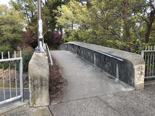
pedestrian bridge that crosses a small access road. This path then dipped down and took me northwest, beneath two overpasses. Arriving then at a
freeway onramp with no crosswalk, I was asked to turn right, and the path continued to
another pedestrian bridge that took me above the freeway ramps and deposited me at the
cul-de-sac of Orinda Way. Orinda Way to a left turn at Santa Maria. Santa Maria to Camino Pablo. This time, instead of walking along the north side of Camino Pablo, and running across the freeway-like road opposite the trailhead, I
crossed at the traffic light. Even though there's no crosswalk, I walked with the green light and made it across in one piece. And that is the last street crossing for awhile, even though the next one is no less harrowing!
I arrived at the
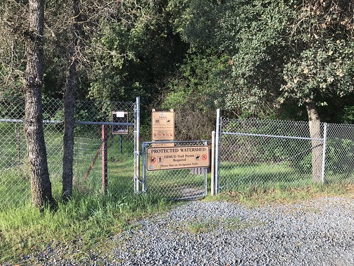
De La Veaga trailhead at 8:48, a gate off of a small gravel turnout, diligently signing the
log book with my EBMUD trail permit number, rejecting the scofflaw ways of my past.
(HERE'S WHERE YOU GET AN EBMUD TRAIL PERMIT) The De La Veaga Trail is only what I would call a
trail for the first half mile or so, and then it intersects and becomes one with a
fire road, which seemed to be recently re-graded and
widened. The fire road winds it's way lazily up grassy oak studded hillsides and
beneath massive high voltage power lines. Views begin to open up back to the east, and soon
majestic Diablo comes into view. Eventually the road gains a ridge, and I crossed through another cattle gate (but no cows around today at all). To the south, I looked down into the lush spring green
Siesta Valley, with Las Trampas in the distance. To the west, the familiar ridgeline of the Oakland and Berkeley hills played out in front of me. At this point I encountered the only other humans on the DLV trail, three hikers headed in the opposite direction.
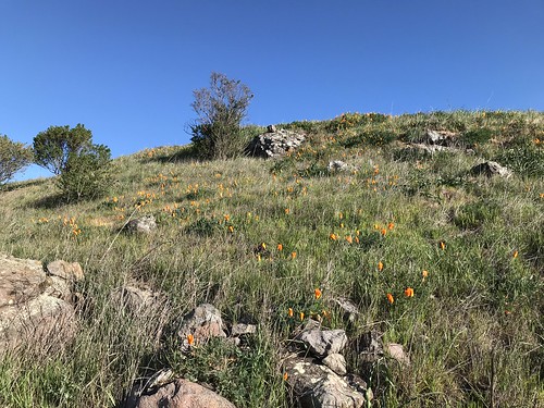
The fire road dipped down into the northwestern end of Siesta Valley, past some
poppy speckled hillsides, and then climbed back up the more
heavily wooded other side to leave the EBMUD protected watershed and meet the
East Bay Skyline trail. This took me on the final stretch, to the crest of Frowning Ridge, where I emerged into sunlight, and made an unprotected mad dash
across Grizzly Peak Boulevard. Entering the system of trails that leads down Skyline Ridge and Claremont canyon, there is a change of atmosphere. In a zone that is touched by coastal fog, the
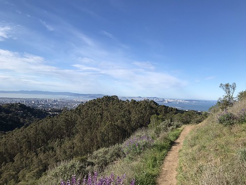
vegetation becomes more lush, and non-native eucalyptus trees are a strong presence. Now comes my favorite part, as I descend the ridge, and around a bend comes a fine view of
bonny old Oakland! And then
San Francisco too!
As I made my way west, down the trail, I decided to stop and verify just what was the geographical feature named
Skyline Ridge, even though I've been there before. It is the eastern, and higher of the two mini hills (that have side trails leading to them) on top of the main ridge. This particular one has two
spirals made of rocks at the top. Hence it's other name, Spiral Knob. Alternately hiking and jogging down towards Berkley now, I officially
entered Claremont Canyon Regional Preserve. The farther down I got, the more hikers and joggers I saw, of course. Getting close to civilization. Down the Stonewall Panoramic trail.
Bloody steep in places, and lots of loose pebbles! I had to be careful not to end up sliding down it on my ass. Popped out of the bottom of the park at Stonewall Road, took it South to Claremont Avenue, and then College Avenue to Rockridge, where I re-entered the BART system after just over two hours of hiking. I still believe this is probably one of the finest urban hikes you can do in the Bay Area, and one of the few in the world where you can ride the subway to the trailhead! Please leave a comment if you know of any other ones!
 |
| Map by Google |


Hard core. That's on my wish list, but I need to toughen up first.
ReplyDeleteAww... man, it's not so bad! I was just checking out your website yesterday to try and figure out how to get up Sugarloaf Hill!
ReplyDelete