

DISTANCE: 5.35 miles
ELEVATION GAIN: 1118 ft.
TIME TAKEN: 1:46
SUMMIT: Round Valley Hill (1,200 ft.)
ROUND VALLEY REGIONAL PRESERVE
CONTRA COSTA COUNTY, CA
SOUNDTRACK: Ratt: Round And Round
PHOTO ALBUM
MAP
Up at 5:30AM, with two goals in mind: explore one of the East Bay Regional Parks on the far periphery, and in the process, get much needed provisions from a suburban grocery store, which might not be as "crazy" as the ones in Oakland are right now. The grocery thing worked out, rolling into a suburban strip mall supermarket in Brentwood at 7:15 AM was a pretty relaxed environment, compared the Covid Chaos back in Oakland.

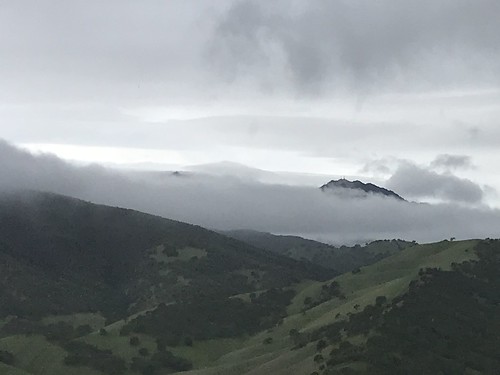
I was hoping that Round Valley Regional Preserve might be well abandoned when I got there at 8:15 AM, with a forecast of rain, but that was not to be. I don't know if it matters anymore that it's a Saturday. Nothing makes sense anymore! But there I was at the trailhead, and I chose to be part of the problem, not part of the solution. At least I was hiking alone, unlike some people. I crossed the bridge and started the main loop, going clockwise on the Hardy Canyon Trail. I guess EVERYONE must do that loop COUNTER clockwise, because I had at least ten fucking trail runners rushing at my face within the first ten minutes. But Round Valley has one advantage for the age of social distance hiking, most trails are doubled or even tripled, a ranch road and one or sometimes even two singe track footpaths / cowpaths all going the same way. So if someone is coming near, you can usually take a different, parallel trail. And go hang out with the cows, because there are lots and lots of cows. The runners tapered off a bit, and a cold wind picked up, as the trail climbed out of Hardy Canyon and up to the saddle next to Round Valley Hill. I cut north on an unofficial trail that led to the top. It was studded with some graceful oak trees and a few rock outcroppings, one of which was the highpoint. Rain had threatened since I started hiking, but never got beyond some scattered sprinkles. From the top of the hill, there was a pretty good view of the surroundings. Clouds shrouded Mount Diablo and Morgan Territory, and distant, ethereal sunlight illuminated the San Joaquin Valley. Socially distanced at last.
FURTHER READING
• Redwood Hikes (they say YES, most people do the loop counterclockwise)
• BA Hiker (another take on the same trail)
 |
| Map background by EBRPD |
No comments:
Post a Comment