

DATE: Wednesday, April 29, 2020
DISTANCE: 15.46 km / 9.61 miles
ELEVATION GAIN: 510m / 1672 ft.
TIME: 3:44
MORGAN TERRITORY REGIONAL PRESERVE
CONTRA COSTA COUNTY, CA
SOUNDTRACK: Sepultura: Territory
SUMMITS:
Bob Walker Ridge: 603m / 1977 ft.
Marsh Benchmark 787m / 2581 ft.
PHOTO ALBUM
MAP 1
MAP 2
Morgan Territory Regional Presereve is an East Bay open space, not quite attached to the south-east corner of Mount Diablo State Park, named for the wayward Alabama colonizer and grizzly bear killer named Jeremiah Morgan. The park was first established in 1976, and encompasses 5,000 acres of rolling hills.
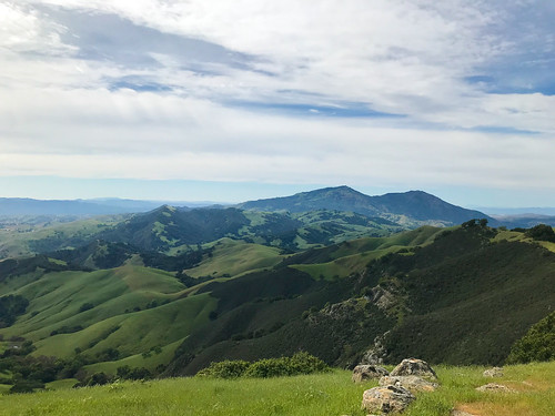
I was back in Oakland. It was day 39 of of Covid-19 lockdown, by my personal count. I wanted to hike, and got up early for that reason, but I could not leave the house. There are strange psychological factors at play in a pandemic. I procrastinated, fiddled around, probably did the dishes or something, and eventually dragged myself out and headed to Morgan Territory for my late start. Not too many cars in the parking lot of the main staging area. I got out an immediately headed north-east on the Volvon Trail. Most of the people I saw that day were near the beginning, and I lost them soon after. It was partly cloudy, breezy, and I was clipping along at a fine hiking pace, once I finally got out there, through the oak studded hills. I wish I'd had a reason to go down Whipsnake Trail, the next intersection, because that's a good name for a trail, but I was headed for Bob Walker Ridge, the only named high point in the whole park, so I turned north on the Blue Oak Trail. Here, I gained a little elevation, and was able to see out east into the central valley. Blue Oak was a winding old farm road, progressing through scattered groves and undulating green hillocks, and it was only a matter of time until El Diablo reared it's massive head above the next ridge. I must say, it was quite pleasantly verdant out there, the grass was tall, and I took note of how it was stirred in the breeze.

When I got to the Volvon Loop Trail, I veered to right, so I could go along the east side of Bob Walker Ridge. I didn't stay on the trail too long before I cut off into the grass to get to the high point of the ridge. There was actually a faint trail leading up to the top, where like so many other East Bay hill summits, an oak thicket and some small rock outrcroppings were present. After this, I went back down (east) to rejoin the Volvon Loop Trail. I went around the north end of Bob Walker Ridge on the trail, and then curved back around the other side, south. Lots of cows on this side. Oh did I mention this is a big cow farm park? When I got down to the big intersection of Volvon Loop, Eagle Trail and Stone Corral Trail, I ran into a group of athletic looking young people, not a mask in sight. I was hoping to keep my distance, and breeze right pass them without a word, but they stopped me to ask a question, something like: "We saw you start at the same time as us, from the parking lot, how long do you think to complete the Volvon Loop?" I replied, maybe two more miles, and they balked. I was surprised, athletic young people should be kicking my ass on this shit1 Look at them, getting out-hiked by a beer swilling, drug taking anarchist! One I was away from the kids, I finally sat down on a boulder and took a break, checking my ankles for ticks. Then it was down the Coyote Trail, out of the meadows and into the trees, following the creek.

The Coyote Trail was a good change from the previous landscape, and a fun walk, shaded under a consistent oak foliage now, and climbing up and down the little rocky steps on the hillside along the mostly dry ravine bed. There was only one problem, and this wa something I'd never seen before, until the pandemic struck, maybe I was just lucky in the past, or maybe this is a new thing, but: people sitting down, taking a break RIGHT IN THE MIDDLE OF THE TRAIL! A SINGLE TRACK WITH ROCKS AND TREES ON BOTH SIDES AND NO ROOM TO GO AROUND THEM! WHAT THE FUCK?! And they act surprised when someone needs to get past?!?! Anyway... I didn't let it ruin my day. I moved on from it ya know? Like ya should, and soon I was back at the parking lot, having completed my loop, and I was faced with a choice: go home now, or add to the hike some more? I had plenty of day left at this point, so I kept going across Morgan Territory Road and up the Clyma Trail now... on my way to Marsh Benchmark. I took Clyma Trail, an old ranch road, seemingly, to the logical conclusion of it's usefulness to me, and bend in the road at it's southwest extremity that was closest to Marsh BM. From there, faint trails in the grass came and went. I followed as best I could, without crossing the fence into private property. Someone's ranch house was eminently visible at the park boundary. If they had been looking off their back porch, they would have seen me. Anyway, I continued up, the way that I found, and soon intersected the service road that leads up to the top. Marsh Benchmark: This is the radio tower crowned hill that lords over the Livermore Valley area on the north side. I had noted this mountain before, driving through the area on interstate 580, and it was satisfying to now be on top.

I was glad I had made the effort to extend the day's hike, now I felt like i had accomplished something, as well as satisfying my mountain hunger. Unlike Bob Walker Ridge, Marsh was a substantial peak with 360 degree views. There was an especially good angle on Mount Diablo and Oyster Point. East, into the Central Valley. South, down to Loma Prieta even. I found the actual benchmark, too. I sat down on the concrete foot of a radio tower and had a snack. From the top of the hill, I saw a much better trail going down the north side, much better than the way I had come up, so If you're keen to go up Marsh Benchmark, look at my map, and go up the north-west way. the way I came down. That is, if you care about being on a trail. Back then, I had an irrational fear of getting ticks, so I was always looking for a way to not go through the tall grass. I wrapped things up at the summit, headed down, and took some pictures of the awesome clouds, and a sturdy footbridge, I got back to the van in the parking lot, and as I drove home to Oakland, contemplated how 2020 would be a lost year for rock and roll.
ON PEAK NAMES
Bob Walker Ridge: Named for nature photographer, environmental activist, San Francisco Sierra Club president, and one of the founders of Sierra Club's Gay and Lesbian Activities Section (GLS), the first such group. Bob's photography brought much attention to the Morgan Territory and East Bay Hills area, and his activism ensured that they would be preserved as parkland. Of all the hills and mountains in California named after dead white guys, I find this to be one of the most unobjectionable!
Marsh Benchmark: If if didn't have the USGS benchmark on top, what would this place be called? Just Marsh? Marsh Mountain? Why does "benchmark" become part of the name, when it has a benchmark on it?
FURTHER READING
•Bay Area Hiker: The usual good descriptions and big photographs
•The Outbound: This describes a similar loop to what I did
•Redwood Hikes: Big photos and hiking recommendations
•Bob Burd: Bob pays a visit to Marsh Benchmark on the way to Oyster Point

No comments:
Post a Comment