
 DATE: Friday, April 24, 2020
ELEVATION GAIN: 426m / 1400 ft.
TIME: 4 hours
SIBLEY VOLCANIC REGIONAL PRESERVE
ALAMEDA COUNTY, CA
CONTRA COSTA COUNTY, CA
SOUNDTRACK: Black Sabbath: Am I Going Insane
PEAKS
“Grizz-Line Hill” 458m / 1504 ft.
“Radio Tower Hill” 457m / 1500 ft.
PHOTO ALBUM
MAP
I was up in the Montclair District of Oakland this Friday morning to have some body work done on my van (it got a kiss from a telephone pole). When I dropped it off, the guy said it would take about three hours, so I decided to go for a hike, of course. It seemed like the perfect time to check out a few more obscure features in the Oakland hills that I had not been to before, or not in a long time. I started out with getting some snacks, and most importantly, water (it seemed like it was going to be a a warm one), from the 7-11. Then I hoofed it up Thornhill Avenue, which began gently, then grew increasingly steep as I approached the top of the ridge. I enjoyed the shade of the abundant landscaping, and the meticulous angles of the midcentury architecture. It wasn’t a bad walk at all, even though there was no sidewalk, the cars were few and not passing too close.
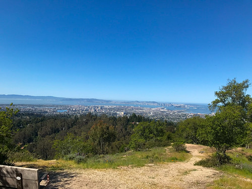
Thornhill to Sobrante Road, to Thorndale Drive, to Elverton Drive and finally, as the landscaping and houses began to thin out, I reached Skyline Boulevard. From Skyline, I scurried up a casual trail on the embankment on the side of the road, which brought me to my first destination, Peak 1504’, which I will heretofore call “Grizz-Line Hill,” because it is sandwiched between Grizzly Peak Boulevard and Skyline Boulevard. There is a possibility that I may have been here in the past, but it was long before I kept track so meticulously of my comings and goings. There were fine, open views to the west, of San Francisco and the Golden Gate, and east to Gudde Ridge running through Sibley. “Grizz-Line Hill” would be a fine place to spend some hours, enjoying the view, reading a book, drinking a beer… there’s even a bench placed there which would abet such activities.
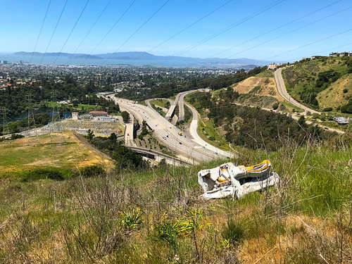
I descended another use trail, on the north side of the hill, to get down to Grizzly Peak Boulevard (which will from now on be referred to as GPB), and walked west, and then north-west, along it. My next destination would be the summit colloquially known as “Radio Tower Hill,” which I had certainly not been to before. GPB, in this section, was blessed with an unofficial sidewalk in the grassy area off to the side, so I had some protection from the traffic as a traipsed along. The mouth of the Caldecott Tunnel spilled out to the west, below, and precarious hillside homes lined the sides of the road. At one point, I came across a massive herd of goats “clearing the weeds” (They were mostly just sitting there! Busted! Get to work!) from a vacant piece of land. I knew that goats were employed for this purpose, but I always imagined a team of three or four goats, diligently scouring the property, not forty goats, mostly just lying around, chomping the occasional weed when they felt like it. Perhaps I caught them on their coffee break.
At a bend in GPB, there is a distinctive outcropping of sedimentary rock, and this was my signal to leave the road and take a use trail up to “Radio Tower Hill.” It was a few minutes up through grass and wildflowers, and then, there I was, at the KPFA transmitter tower, which is a landmark that should be known to anyone who has driven east through the Caldecott Tunnel and looked up. “Radio Tower Hill” indeed! I couldn’t argue. From the top, I had a good look at Barberry Peak, another obscure East Bay hill which I intended to visit soon. Now that I was secure knowing there were no guards on this “private property,” I took the obvious driveway back down to GPB. To continue my journey now, I needed to get back to Skyline Boulevard, which was parallel to GPB, just below, but in order to avoid crawling through people’s backyards, as well as steep hillsides and brush, I backtracked all the way to “Grizz-Line.” It was a nice day out, and I wasn’t in a hurry, so I took my time.

Back down on Skyline, which also has a pretty good sidewalk/trail along it, I hiked west until I hit Broadway Terrace, went downhill just a wee bit, then went over the guardrail and down a use trail on the grassy hillside. The last piece in the puzzle of my loop, I intended to follow the big power lines down to the bottom of the ridge. It turned out that there was a clear path all the way. The use trail led down until I got to a big water tank on my left. There, it met up with s PGE& access road. There were some workers around there doing some tree maintenance, but if I was trespassing, they didn’t care. At some point I came to a gate in this road, which would have blocked cars, but was easily walked around by a pedestrian. I continued to follow the service road. The PG&E property is kind of a no man’s land in the Oakland Hills, no houses or structures beneath the power lines, no trees either. No inhabitants, but also not a park. Private property, but obviously, regularly trespassed upon by walkers.
Before too long, I came to another gate, this one wide open. They’re obviously not trying too hard to keep people out of here. The PG&E road came to an end again, or turned off to the south, and I continued on my planned trajectory, following a use trail that led downhill, across a grassy hillside, still beneath the power lines. On this hillside, I found an abandoned, destroyed couch. In the middle of nowhere, and I wondered who put it there, and why? It wasn’t a dumping ground, there was no other trash. Perhaps someone's onetime hangout spot, but a hell of a long way to carry a couch. I was now reaching the bottom of the hill, approaching the terminus of the power lines at the sub-station by Lake Temescal, and it was time to get out of powerline land. There was an access gate to the south, which I went around, and I was on Pali Court, back in the suburban neighborhood of “Glen Highlands,” just north-west of Montclair. I felt like I had unlocked a key to this previously mysterious section of the East Bay hills. By now, I had gotten the call that my van was done, so I walked back through the quaint, hilly neighborhoods to my starting point.
ON PEAK NAMES
“Grizz-Line Hill”: As far as I know, this bump doesn’t have a name, which is surprising, (to me anyway, I’m always surprised at how many peaks don’t have names) because it’s got a nice bit of prominence and a killer view. “Grizz-Line” is a portmanteau I created of Grizzly Peak Boulevard and Skyline Boulevard, and it is technically within Sibley Regional Park. If anyone knows a better name for it, please tell me!
“Radio Tower Hill”: I’ve read about it being called this, maybe only on Oakland Geology (see below) so I’m just gonna stick with it for now.
FURTHER READING
•Oakland Geology: A little blurb about “Radio Tower Hill”

No comments:
Post a Comment